
![[Washington & Oregon] Amer. Sep. No. 38. Partie Des Etats-Unis By Philippe Marie Vandermaelen](https://storage.googleapis.com/raremaps/img/small/93549.jpg)


|
||

|

|
|

|
The Best Large Format Map of Its Generation
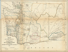
Fine old color example of Vandermaelen's map of parts of Washington and Oregon from 42 to 48 degrees latitude, and from 120 to 130 degrees longitude, one of the most detailed maps of the period for this region and the only map to focus narrowly on this section of the Northwest.
A note off the mouth of the Columbia River references Captains Lewis & Clarks' arrival on November 13, 1805 and departure on April 23, 1806. The map also provides a meticulous account of hte Indians tribes in the region.
The map extends north to the southern part of Puget Sound, and appears to reach beyond Seattle and possibly to Everett, Mt. Rainier, Mt. St. Helens, and Mt. Jefferson. Locates Forts Astoria and Clatsop at the mouth of the Columbia River. A table gives the populations of 10 Indian tribes and numerous tribes are located throughout the map. The Atlas Universel was the first atlas to present all the maps on the same scale (1: 1,641,836), with each map covering an area of approximately 20 degrees longitude (from Paris) and 6 degrees of latitude. Also considered to be the first lithographic atlas ever published. Of these large-scale and highly detailed maps, Wheat said "No mapmaker had previously attempted to use such a large scale for any western American area."
While it is generally believed that there was only one edition of Vandermaelen's atlas, we have over the years identified 2 states of many of the maps. One state includes printer's details below the lower neatline, the second state does not.
The present example is the second state of the map. The states can be differentiated as follows:
- Vandermaelen credit and 1825 date at bottom left
- Significantly improved topographical details and "No 38 in title in an equal sized font"
- Title charged from "Partie L'Oregon" to "Partie des Etats Unis"
Philippe Marie Vandermaelen (1795-1869) was a Belgian cartographer and geographer known for his pioneering use of technology and his leadership in establishing the important Establissement geographique de Bruxelles. Born in Brussels, Philippe was obsessed with maps from a young age. He taught himself mathematics, astronomy, and mapmaking and plotted the battles of the Napoleonic wars avidly. He took over his father’s soapmaking business briefly in 1816, but then turned it over to his brother in favor of cartography.
From 1825 to 1827, he released his first atlas, the Atlas universal, which was well received. It was sold in forty installments of ten maps each, with 810 subscribers listed. The atlas contained 387 maps in six volumes at a uniform scale of 1:1.6 million. The maps were intended to be joined and together would create a globe 7.755 meters wide. It was the first atlas to show the entire world on a large uniform scale and was the first atlas produced using lithography. This project served as Vandermaelen’s gateway into intellectual life, gaining him membership in the Royal Academy of Sciences and Belles-Lettres of Brussels (1829).
In 1830, Vandermaelen inherited a laundry from his parents which he converted into the Establissement geographique de Bruxelles, or the Brussels Geographical Establishment. His brother, Jean-Francois, also established a botanical garden on the site. The Establishment had its own lithographic press, one of the first to use the technology for cartography and the first in Belgium. They produced textbooks, surveys, and especially maps of Brussels to be used for urban planning. The complex also housed schools, an ethnographic museum, and a library open to the public. Vandermaelen was passionate about geographic education and saw the Establishment as an open place where people could learn about the world.
In 1836, he was knighted for his services to geography and the intellectual community of Belgium. He died at age 73 in Molenbeek-Saint-Jean, near the Geographical Establishment that he founded. After Vandermaelen’s death, the Geographical Establishment declined, closing its doors in 1880. The extraordinary collection they had amassed passed to several institutions, most importantly the Royal Library of Belgium.
![[ Oregon ]](https://storage.googleapis.com/raremaps/img/small/96568.jpg)
![[ Pacific Coast Pictorial Road Maps ] Scenic Touring Scout](https://storage.googleapis.com/raremaps/img/small/101745.jpg)