|
||

|

|
|

|
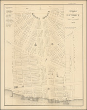
The First Map of Detroit
Fine example of the first separately printed map of Detroit, published by Bellin in his Petit Atlas Maritime.
Bellin's map is based on surveys made by French engineer Gaspard-Joseph Chaussegros de Lery (1721-97), completed just before the start of the Seven Years War (French & Indian War in America). The map shows the Detroit River in the general vicinity of Detroit, including the many islands and safe anchorages, as well as farms, villages and other landmarks along both shores. The town of Detroit appears as "Habitations" on the north bank of the river, surrounded by farms.
The large inset plan shows the fortified town of Detroit in detail, about 400 by 600 feet with very narrow streets. Buildings are shown in plan view, with five of the most important identified by name.
Detroit was founded in 1701 by French-Canadian settlers, under Antoine de la Motte Cadillac. Established at an important location on the Detroit River between Lakes Erie and Huron, Detroit was for decades one of North America's most strategically-significant settlements, controlling a key route from Canada to the Old Northwest and the Mississippi Valley.
By the time of its capture by the British during the French & Indian War, it had grown to some 800 inhabitants, making it the largest settlement between Montreal and New Orleans.
Jacques-Nicolas Bellin (1703-1772) was among the most important mapmakers of the eighteenth century. In 1721, at only the age of 18, he was appointed Hydrographer to the French Navy. In August 1741, he became the first Ingénieur de la Marine of the Dépôt des cartes et plans de la Marine (the French Hydrographic Office) and was named Official Hydrographer of the French King.
During his term as Official Hydrographer, the Dépôt was the one of the most active centers for the production of sea charts and maps in Europe. Their output included a folio-format sea atlas of France, the Neptune Francois. He also produced a number of sea atlases of the world, including the Atlas Maritime and the Hydrographie Francaise. These gained fame and distinction all over Europe and were republished throughout the eighteenth and even in the nineteenth century.
Bellin also produced smaller format maps such as the 1764 Petit Atlas Maritime, containing 580 finely-detailed charts. He also contributed a number of maps for the 15-volume Histoire Generale des Voyages of Antoine François Prévost.
Bellin set a very high standard of workmanship and accuracy, cementing France's leading role in European cartography and geography during this period. Many of his maps were copied by other mapmakers across the continent.
![[ First map of Michigan Territory published in Europe ] Carte Geographique, Statistique et Historique De Michigan](https://storage.googleapis.com/raremaps/img/small/99266.jpg)