|
||

|

|
|

|
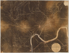
An Important Early French Map of the American Revolution -- Large Inset of the Yorktown Theater of War
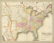
Showing the rare separately issued map of the United States, among the first to show the newly created states, with a fine contemporary plan of the French Blockade and combined French & American Siege of Yorktown.
Fine large-scale important French map for the American Revolution which is significant for several reasons. (1) The large inset is one of the best French printed plans of the Siege of Yorktown, in which both the French army and Navy played a conclusive role. (2) The larger general map is one the earliest to show the boundaries of the new United States. The title notes [in French] that the map lays down the limits of the United States established by the proposed treaty of peace. Thus the boundaries must have been taken from the preliminary Treaty of Peace, signed November 30, 1782, and the map published prior to the signing of the formal Treaty on September 3, 1783. The title also notes that the printed map was constructed by René Phelipeau, professor at the Royal Military College in London, based in part on an earlier map by J. B. Nolin, drawn from English manuscripts at the end of the French & Indian War. Phelipeau's completed map was never printed in England and must have been immediately forwarded to Paris for publication.
The map is quite rare. When the Clements Library acquired its copy in the summer of 1965, it was described as "an important map … known in only one other copy, at the Library of Congress." A handful of additional examples have surfaced since, at the New York Public Library, the Huntington Library, Princeton, the Birmingham (Ala.) Public Library, and the Burton Historical Collection at the Detroit Public Library. To our knowledge, there is no copy at any Virginia institution, with just one other example offered for sale within recent memory. That example was added to the distinguished collection of Virginia and related maps formed by Bill Wooldridge. Wooldridge reproduces both the general map and the Virginia inset in Mapping Virginia (plates 152 and 152a).
The inset plan of the 1781 Siege of Yorktown is one of the largest of the small handful of printed French plans of that battle. It is second only in importance to Esnauts & Rapilly's Carte de la Partie de la Virginie… (dated variously 1782 to 1784). The inset shows the lower Chesapeake Bay with good detail and more accuracy that the Esnauts & Rapilly. The lower courses of the major rivers are laid down with the seats of many planters identified by name. The inset contains a great deal of military information, including the lines of the French and British fleets at the decisive naval battle at the mouth of the bay. A key identifies twelve positions taken up by the French and Americans at Yorktown and Gloucester Point.
The map contains a large amount of additional information relating to the Revolutionary War. Scattered across the Northern Colonies and along their coasts, are notations on various earlier military engagements dating from 1775 to 1778. There are no such notations for the later Southern Campaigns. The map includes a well-developed road network that extends into the Ohio Valley and beyond. There are a number of notations in that region that relate to events of the French and Indian War.
The proposed boundaries for the United States are accurately laid down by a line of small crosses overpainted in red and green. The major exceptions are the assignment of much of northern New York State to the British and that the boundary between Georgia and Spanish Florida is pushed northward to the Altamaha River. This interpretation of the boundary is more accurate than that on the famous Red Lined Map (John Mitchell), used by the British during the treaty negotiations (British Library). The boundaries of the various colonies are shown in yellow, with the territories of Virginia and the Carolinas extended to the Mississippi.
A map of the highest importance.