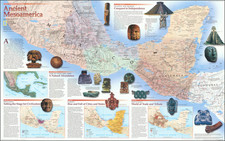
|
||

|

|
|

|
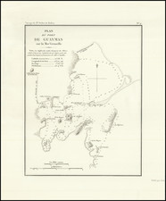
Finely-Executed, Early Manuscript Plan of Puerto Escondido, in the State of Oaxaca
Good example of a survey of Puerto Escondido, most likely sketched in the early-nineteenth century. The plan shows the bay with detailed soundings and is one of the earliest surveys to show such carefully measured and recorded information.
The bay is shown on a northern orientation, with soundings marked with numbers and the quality of the sea floor marked with letters. A scale is in the lower left corner. In the upper right is an explanation of the plan. In Spanish, it reads:
Plano del puerto escondido situado sobre el Océano Pacifico en el Estado de Oaxaca Lat. N. 15 ° 54'40" y 70 ° 07'35" Long. E del Meridiano de S. Blas.
Nota. Los números de la sonda son brazas. A las 4 h. 40 m. de la tarde aumenta el flujo del mar 4p. y 9 L de Burgos.
In English:
Plan of Port Escondido situated on the Pacific Ocean in the state of Oaxaca, lat[itude] N[orth] 15°54'40" and 70°07'35" Long[itude] E[east] of the meridian of S[an] Blas.
Note. The numbers of the sounding are in fathoms. At 4:40 PM the flow of the ocean increases 4p. and 9 L de Burgos.
The references to Burgos in the note and the scale indicate a local variation on customary Spanish measurements, specifically those used in Burgos in northern Spain. This could indicate the region of origin or education of the author.
The map is on paper with the watermark of Giovanni Cini, which commenced business in 1807.
Puerto Escondido
As the plan explains, Puerto Escondido is a port on the western coast of Mexico, facing the Pacific Ocean. The area was inhabited by indigenous communities for generations before the Spanish invaded. Although the Spanish were aware of the bay and appreciated its importance as a viable port, it was not home to any sizeable permanent settlement during the pre-Hispanic or colonial periods. Settlement was not viable due to a lack of potable water near the bay.
Although the bay's name, Bahia de la Escondida, would suggest its protected geography, the name refers to a woman who sought shelter there, una escondida. Supposedly, while Sir Francis Drake and his brother were terrorizing Spanish settlements along of the Mexican coast, they kidnapped a Mixtec woman from Santa Maria Huatulco. While anchored in the bay, the woman escaped by swimming to shore and disappearing into the overgrowth near shore. Pirates took up the legend and the name became common nomenclature.
By the twentieth century, the bay was called Punta Escondida and, then, Puerto Escondido. Intermittently it was used as a port to ship coffee and a fishing camp. Eventually, some, such as Nazario Castellanos and Escolástica Valencia, both night watchmen for the nearby coffee plantations, settled and became a town's first residents. A permanent settlement was established only in the 1930s; since then, the port has grown, and the area has become a site popular with surfers and tourists. This plan is a fascinating glimpse into the bay's early history.
![[Manuscript Map, Michoacan, Mexico]](https://storage.googleapis.com/raremaps/img/small/65663ba.jpg)