


|
||

|

|
|

|
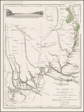
French Map of the Boxer Rebellion, showing European Concessions and Focussing on the Area between Shanghai and Beijing.
Hansen's color-lithographed map of the theater of the Boxer Rebellion, with an inset map of East Asia and another that is a plan of Beijing and the Imperial Palace. The map was published in Paris in 1900.
The following foreign concession are noted:
- German concession around Kaio-tcheou Bay.
- English concession around Wei-hai-wei.
- Russian concession around Port Arthur.
- French concession at Kouang-tcheou.
- English concession at Hong Kong.
- Portuguese concession at Macau.
These foreign concessions were a major impetus for the Boxer Rebellion. The Boxer Rebellion was a violent anti-foreign, anti-colonial, and anti-Christian uprising that took place in China between 1899 and 1901. The Rebellion occurred at the end of the Qing Dynasty and hastened its demise. The Eight-Nation Alliance of European powers, Japan, and the United States put down the rebellion and imposed harsh penalties on the central government. The French took an active role in the hostilities, supplying 3,000 of 51,755 total troops for the Alliance.
The map legend is quite detailed. It shows Navigable Rivers and Canals, built, planned and under-construction Railroads, telegraph lines, large roads, French and Christian missions (another impetus for the rebellion), borders, and forts.
![[ Mongolia & China ] Tartaricus](https://storage.googleapis.com/raremaps/img/small/97226.jpg)
![[ Japan and East Coast of Korea ] Charte Der Iapanischen Inseln . . . 1811](https://storage.googleapis.com/raremaps/img/small/97099.jpg)
![[Macao, Hong Kong & Environs] Carte de L'Entree de la Riviere De Canton dans la Chine](https://storage.googleapis.com/raremaps/img/small/74473.jpg)
![[Shanghai & Yangtze River] Nanking, et Honan Provincie della China . . .](https://storage.googleapis.com/raremaps/img/small/46304.jpg)