|
||

|

|
|

|
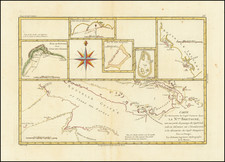
An Annotated American Sea Chart of Luzon and Environs From the Spanish American War --
Rare US Navy Hydrographical Office chart of Luzon and the northern parts of the Philippine Islands, published during the Spanish American War.
The present example was sold privately in San Francisco by J.C. Pascoe, a Chart and Bookseller operating at 305 Battery Street and bears a stamp noting:
This chart corrected to Sep 21, 1899 The Date of Issue From the Hydrographic Office
Detailed map focusing on coastal features, but including interior topographical details, primarily in the north and west of Luzon.
The map is drawn from Spanish and English Sources, including:
- Claudio Montero (1859)
- Edward Belcher (1845)
- Francisco Coello (1852)
Includes inset maps of:
- Port of Dimalansan
- Port of Bikobian
- Port of Boliano
- Musa Bay
- Port San Pio V.
- Port San Vicente
- Port Sual
Rarity
The chart is extremely rare. We locate only the copy in the Newberry Library. No auction or dealer catalog records.
![[Manila]. Die Befestigung der Hauptstadt Manila (Philippinen)](https://storage.googleapis.com/raremaps/img/small/86077.jpg)
![Il Disegno Della Terza Parte Dell' Asia [Gastaldi's Wall Map of SE Asia with extra panels!]](https://storage.googleapis.com/raremaps/img/small/30554hbp.jpg)