
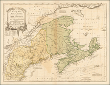
![[First State of the Popple Key Sheet] A Map of the British Empire in America with the French and Spanish Settlements adjacent thereto by Hen. Popple. By Henry Popple](https://storage.googleapis.com/raremaps/img/small/92714.jpg)


|
||

|

|
|

|
Key Sheet to Henry Popple's Wall Map of the British Colonies in North America
A gorgeousexample of Henry Popple's Key Sheet, which was sold separately and bound in with his 20 sheet map of North America, one of two most important general maps of North America issued during the 18th Century.
Henry Popple worked with the Board of Trade & Plantations in 1727, during a period when boundary disputes in the colonies began to accelerate the need for detailed maps. In 1730, the Board began requesting detailed maps of the entirety of the provinces and contiguous French and Spanish Dominions. Popple issued an announcement for the map in 1731, but did not complete work until 1733. The map was not a commercial success and did not sell well until after William Henry Toms and Samuel Harding took over publication in 1739. With the outbreak of the War of Jenkin's Ear, the map saw its commercial successes soar. In 1746, the rights to the map passed to Willdey and Austen, who published it until Austen's death in 1750.
This is the first state of Popple's Key Sheet, with no additional place names appeareing on the northwest coast of Cuba, other than Havana and Cabo S, Antonio, as identified by Babinski.
The map includes 4 views (New York Harbor, Québec, México City and Niagara Falls) and 17 Harbor Plans.
Popple's Map of North America
Popple's 20 sheet Map of the British Empire in America is without question one of the two most important large format maps of North America published in the 18th Century. Along with John Mitchell's Map of the British & French Dominions in North America . . . (1755), the map was a profound statement of England's designs for dominance of the North American continent, at a time when colonial control of North America was by no means certain.
Henry Popple worked with the Board of Trade & Plantations in 1727, during a period when boundary disputes among both the colonists and with the French began to accelerate the need for detailed maps. In 1730, the Board began requesting detailed maps of the entirety of the provinces and contiguous regions. Popple issued an announcement for his map in 1731, but did not complete work on his 20-sheet map until 1733. Despite his connection to the Board of Trade & Plantations, Popple's map was not a commercial success and did not sell well until publication of the map was taken over by William Henry Toms and Samuel Harding in 1739. With the outbreak of the War of Jenkin's Ear, the map saw its commercial successes soar. In 1746, the rights to Popple's map were sold to Willdey and Austen, who published the map until Austen's death in 1750.
As noted by Barbara McCorckle in America Emergent,
Little is known of Henry Popple except that he came from a family whose members had served the Board of Trade and Plantations for three generations, a connection that must have been a factor in his undertaking the map, his only known cartographic work" (McCorkle 21.)
Popple produced this map under the auspices of the Lord Commissioners of Trade and Plantations to help settle disputes arising from the rival expansion of English, Spanish and French colonies. At the time of its publication, "France claimed not only Canada, but also territories drained by the Mississippi and its tributaries - in practical terms, an area of half a continent" (Goss The Mapping Of North America p.122.) .
Popple's map was also the first English map to name all the original thirteen colonies and one of the first maps to show Georgia. The new Colony of Georgia was chartered in London in July 1732, but developed only in early 1733, with the landing of James Edward Oglethorpe and his small party of 120 colonials. Oglethorpe returned to England in 1734 and met with the King on July 20, 1734, showing him "several charts and Curious Drawings relating to the new Settlement of Georgia". The same charts and maps must have been almost immediately made available to Popple by Oglethorpe, as Popple immediately incorporated this new information into a corrective paste-down mounted on Sheet 10 in State 3 of the map. The new information regarding Georgia was then engraved onto the map in State 4 published in late 1734 [Babinski, note 12, 13]. The new Colony of Georgia was considered by the British as an attempt to create an important protective buffer between the more densely populated English Colonies in the north and the Spanish in Florida.
Popple's map was intended among other things, to provide a large format and up to date map of the region in order to better understand and demarcate the rival claims. On close examination, an engraved dashed line identifying the boundaries of the colonial powers can be seen. However, to facilitate a clearer visual depiction of these boundaries, Popple devised a color scheme for depicting the claims of the various colonial powers. As noted by Babinski, in his masterly monograph on Popple's map:
The typical coloring of fully colored copies ... is described best by a contemporary manuscript legend on the end-paper affixing the Key map to the binding in the King George III copy at the British Library: "Green - Indian Countrys. Red - English. Yellow - Spanish. Blue - French. Purple - Dutch."
The careful demarcation of the disputed areas by color makes identification of whether a particular location was in one or another 'zone' a great deal easier. Thus the full original color examples are particularly important in facilitating the graphical depiction of the international land disputes of the time.
Popple's map was both a cartographic landmark and a visual icon among the social elite of the British Colonies. As noted by Bruckner in The Geographic Revolution in Early America. . .
British Americans frequently imported imperial maps during the eighteenth century. Decorative wall maps showing British possessions in North America were favorite articles, purchased primarily by the colonial elite. Strategically displayed in formal settings of the home or provincial office, these maps painted bombastic scenes of territorial conquest and signified the range of the British Empire. For example, maps like Henry Popple's Map of the British Empire in America (1733) reached American audiences upon special orders by the Board of Trade and Plantations, and colonial politicians like Benjamin Franklin eagerly requested Popple's map for public display.
The Key Sheet, like the 20 sheet wall map, is rare on the market. This is the third example we have offered in the past 20 years.
![[German Northern Pacific Promotional Tract] Die Nordliche Pacific Eisenbahn; Ihre Route, hulfsquellen, fortschritte & Gefchafte. der neue Nord-Westen und seine grosse Verkehrs-Strasse.](https://storage.googleapis.com/raremaps/img/small/83777.jpg)