|
||

|

|
|

|
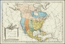
Remarkable Manuscript Map of North America Up To 1848.
Highly detailed German language manuscript map of North America, drawn with meticulous detail.
The primary focus of the map seems to be the regional of the discovery, exploration and geo-political boundaries of North America. The table at the right locates the following regions:
- United States
- Republic of Mexico
- Republic of Central America
- Spanish Colonies
- English Colonies
- French Colonies
- Dutch Colonies
- Russian Colonies
- Danish Colonies Swedish Colonies
- Beglian Colonies
- bedeckt reiche zur zeit der Entdeckung
At the bottom right, the map shows an inset of the United States, broken up into English and French colonies, as existed prior to the French & Indian War. The names of the American Colonies are given, along with a detailed listing of indigenous Indian Tribes.
In the main map, the list of discoveries noted dateds back to Columbus, with many of the Caribbean Islands noting both the years of discovery and the earliest European settement dates.
The Mormon state of Deseret (1848) is shown and the date of the creation of every state in the Union is given up to 1848.
The information in the Arctic Regions is given with meticulous detail, with more than 2 dozen of points and dates of discovery given from the 16th Century to the 1840s, although we found no reference to Franklin.
One of the more remarkable bits of Colonial history given includes Colonia Santo Thomas (Santo Tomas, Guatemala Colony, King Leopold I of Beligum, 1842)
This is one of the most remarkable manuscript school maps we have seen.
![Charte von Nord-America Prag 1818 [Rare Alaska Inset Map]](https://storage.googleapis.com/raremaps/img/small/72184.jpg)
![Oceani Occidentalis Seu Terrae Novae Tabula [The Admiral's Map]](https://storage.googleapis.com/raremaps/img/small/102935.jpg)