The item illustrated and described below is sold, but we
have another example in stock. To view the example which
is currently being offered for sale, click the
"View Details" button below.


|
||

|

|
|

|
Stock# 54042
Description
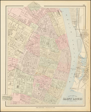
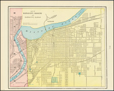
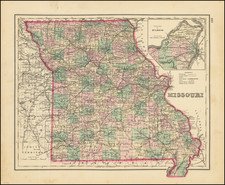
Highly detailed map of Missouri, colored by counties and showing towns, roads, railroads, Post Offices, etc. Inset of the Plan of Vicinity of St. Louis.
O.W. Gray Biography
O. W. Gray was a publishing firm based in Philadelphia. Later, they published as O. W. Gray & Son. They published atlases in the late nineteenth century. Gray's National Atlas was one of the most successful commercial ventures of the 1870s and one of the last to employ hand coloring on maps.

![[ Missouri named State of Jefferson ] Etats-Unis par A.M. Perrot](https://storage.googleapis.com/raremaps/img/small/99019.jpg)
![[Missouri, Illinois, Indian Territory, Kansas, Nebraska, Iowa] Amer. Sep. No. 49. Partie des États Unis](https://storage.googleapis.com/raremaps/img/small/74904.jpg)