|
||

|

|
|

|
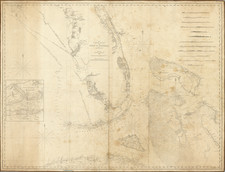
George Gauld's Landmark Chart of the Gulf Coast
Gauld's map of the Gulf Coast is the finest and most detailed general charting of the region undertaken during the first part of the 19th Century. Initiated shortly after the conclusion of the French & Indian War, Gauld's chart remained the most detailed general chart through the American Revolution and the Louisiana Purchase to the establishment of a boundary at the westernmost part of the region upon the culmination of the Adams Onis Treaty in 1819.
Gauld's charting of the Gulf Coast existed only in manuscript format from the conclusion of the American Revolution until 1803, when it was published posthumously by William Faden. Originally published one month after President Thomas Jefferson dispatched James Monroe to France for the express purpose of purchasing New Orleans and all or part of the Floridas from Napoleon, the importance of Gauld's map as a source of information for the region was immediate. For example, the chart was discussed in correspondence between Jefferson and US agent William Claiborne as early as August 1803, shortly after the completion of the Louisiana Purchase.
Gauld was assigned by the British Admiralty to chart the waters off of West Florida between 1764 and 1771. He was taken prisoner by Spanish forces during the Siege of Pensacola in 1781. As noted by the Historic New Orleans on line exhibit for Gauld's map:
From 1764 to 1771, Scottish-born surveyor George Gauld (1731-1782) devoted his professional life to exploring and charting the northern coast of the Gulf of Mexico. Following the British acquisition of West Florida, in 1763, officials recognized the need for better intelligence concerning the "Isle of Orleans" and adjacent waterways-areas they thought might one day be navigated by British merchants or ships of war. Gauld was commissioned to map the coastal areas of newly Spanish Louisiana and British Florida and spent eight years surveying them firsthand. After hostilities erupted between Britain and Spain, Gauld was captured in Pensacola, in 1781, by Spanish forces under the command of Bernardo de Gálvez. He was eventually freed and allowed to return to England, where he died in 1782.
The quality of this survey and others by Gauld attracted the attention of geographer and publisher William Faden (1749-1836), who issued the surveyor's work posthumously. Gauld's monumental chart of the coasts of West Florida and Louisiana, which was issued in 1803, was engraved and printed on four large sheets. The entire chart, when assembled, measures over ten feet long. It is the crowning achievement of Gauld's life's work, encompassing over 850 nautical miles of the northern Gulf Coast and delineating bays, rivers, and lakes, whose depths and bottom characteristics are included in the rare admiralty chart. Commanders of the 1814 British expedition against New Orleans used the chart to plot their route to the city via Bayou Bienvenue.
Surveying The Gulf Coast
Following the conclusion of the French & Indian War (Seven Years War) the British and their ally Prussia emerged victorious. Spain had joined the war on the side of France in 1762 and invaded Portugal, an ally of England. In 1762, British and American colonial forces had captured Spanish Havana.
At the Treaty of Paris signed March 10, 1763, France's colonial reign in the New World ended. However, before the signing of the Treaty, to reward Spain for her support during the war and to restore Bourbon political ties, Louis XV of France gave Louisiana Territory, including the "Isle d'Orleans," to his cousin, Charles III of Spain, under the Treaty of Fountainbleau, which had been secretly signed on November 13, 1762.
In order to recover Havana, the core of Spanish colonial power in North America, Spain immediately ceded a portion of her newly acquired colonies to Great Britain. Spain retained the Isle d'Orleans and the Louisiana territories west of the East Pearl River.
The exploration and mapping of the Mouth of the Mississippi River became a British military priority. George Gauld, the Surveyor for the British Government in West Florida, began mapping the northern Gulf Coast in 1768. Gauld eventually surveyed, sounded, and charted Lake Borgne, Lake Pontchartrain, Lake Maurepas, the Rigolets, Chef Menteur, Pass Manchac, the Pearl River, Bonfuca Creek, the Lacombe River, the Tickfaw River, the Natalbany River, and the Iberville River. His efforts yielded in the most accurate and comprehensive charting of the northern Gulf Coast produced during the 18th century.
In addition to surveying and mapping the newly acquired territory of British West Florida, the government encouraged the settlement of the region. The first governor of British West Florida, George Johnston, (1763-1766) provided free grants of land to retired British officers and soldiers so that each officer received 5,000 acres; captains were allotted 3,000 acres and soldiers 300 acres (Abstract of British Grants of Land in West Florida, 1766-1777, volume 15). (Note, however, that most of the British land grants along the Pearl were only 2000 acres; see below). As the American Revolution progressed in the northeast, many British citizens, veterans and loyal Tories found a safer haven in British West Florida and began settling in considerable numbers along the entire Mississippi, Alabama and Florida Gulf Coast.
Gauld's Map
The importance of the Gauld Map of the Gulf Coast in the history of the region cannot be understated. Following the Louisiana purchase, President Thomas Jefferson wrote letters to William C.C. Claiborne in Natchez on July 17 and July 18, 1803, requesting the best available information regarding Louisiana. Claiborne replied on August 24, 1803 as follows (complete text at the bottom):
Dear Sir,
My Letter of the 12th Instant, acknowledged the receipt of your agreeable favours of the 17th & 18th of July;-Since which I have turned my attention, to the several subjects embraced in Queries relative to Louisiana, and I now lay before you, the result of my inquiries and reflections-
1st. What are the best Maps general or particular of the whole or parts of the Province? Copies of them if to be had in print?
Ansr. There are I believe, none extant that can be depended upon- I have been told, there are two maps of the Province by Men of the names of Romane and Gould [sic].
Gauld's map of the Gulf Coast survives in at least 2 known states:
- William Faden: 1803
- William Faden "Second Edition": 1820 (no complete copies located)
- William Faden / British Admiralty: 1823
It would appear that Faden updated portion of the map in 1820, prior to the sale of the chart to the British Admiralty. The 1820 updates detailed cultural information along the Mississippi and Iberville Rivers in Louisiana, not contained on the original publication of 1803.
The British Library also notes and edition of 1807, which it describes as "A new edition, much enlarged, of the second part of the North American Pilot: for New England ... Florida, etc."
The 1823 edition of the map incudes significant improvements from the 1803.
Rarity
This 1823 edition of the Gauld Chart is extremely rare. OCLC locates only the example in the National Library and Archives of Quebec. The Library of Congress also holds a copy of the 1823 edition of the map.
William Claiborne to Thomas Jefferson Letter
From William C. C. Claiborne
Near Natchez August 24th 1803
Dear Sir,
My Letter of the 12th Instant, acknowledged the receipt of your agreeable favours of the 17th & 18th of July;-Since which I have turned my attention, to the several subjects embraced in Queries relative to Louisiana, and I now lay before you, the result of my inquiries and reflections-
1st. What are the best Maps general or particular of the whole or parts of the Province? Copies of them if to be had in print?
Ansr. There are I believe, none extant that can be depended upon-I have been told, there are two maps of the Province by Men of the names of Romane and Gould (sic). That of the former is supposed to be the best and I have been promised a copy of it-I am also informed, that a number of partial, but accurate Geographical sketches of that Country, have been taken by different Spanish officers, but that it has been the Policy of their Government, to prevent the publication of them. A General work of the same nature, is said to have been undertaken by the French, when they were formerly Masters of the Country, but it was never finished. An ingenious Correspondence of mine residing at Nachitoches on the Red River, informs me, that he has nearly completed an accurate Map of the Country between the Mississippi and the River Grand, including the Province of Sta. Fee. I will endeavour to procure a copy of that map, and should I succeed, will forward it to you. And also that of Romane should it be procured for me, according to promise.
2d. What are the Boundaries of Louisiana, and on what Authority does each portion of them rest?
Ansr. On this question, I have not been able to obtain any satisfactory information. It is understood that by the Treaty of 1763 the Island of New Orleans was the only tract of Country east of the Mississippi, included in the Province of Louisiana as then ceded by France to Spain.-It is related to me on the authority of the oldest setlers in this Territory, that some time previous to that Treaty a design was formed of Running a Boundary line on the west of Louisiana, between the French possessions and those of Spain, and that the Mouth of the Sabine River which disembogues itself into the Bay of St. Bernard in the Gulf of Mexico, was fixed upon as the Point from which the line should set out. The persons appointed to run the line, accordingly proceeded thence up the Sabine River as part of the Western Boundary of the French Province, to a place where they erected a small fort, and fixed in the ground some small leaden posts; The distance of that Fort from the Mouth of the River, I have not learned-from the fort it appears they left the River, and run the line (in what direction I am ignorant) 'till it intersected a Creek called Bayau Pierre, about five leagues N.W. of Nachitoches. Here the line was discontinued, but for what reason I have no information. It may perhaps be necessary to add, that the Post of Nachitoches is situated on the Red River, about 180 miles from its Mouth, and between 150 & 160 miles from Natchez over land-such is the imperfect knowledge I have been able to acquire on this subject, notwithstanding the utmost diligence of inquiry which I have exerted in this vicinity. Mr Clarke from the local advantages which he may avail himself of in this particular, will no doubt furnish you with an account more accurate and copious.
3d. What is the extent of sea coast from the western mouth of the Mississippi called Peakemenes River?
Ansr. The Bay of St. Bernard has been seldom navigated, and the Coast consequently is but little known-But the distance required by your question is conjectured to be about 200 miles.
4th What is the distance from the same mouth due west to the Western Boundary?
Answer The distance has probably never been measured But an old Inhabitant here, who calculates by days Journey supposes it to be about 160 miles.
5th. "Into what divisions is the Province laid off?"
Answer There are ten Divisions; viz The Island of New Orleans, Point Coupee, Atackapas, Apaulousas, Red River, Ouachetas, Concord, Arkansaws, New Madrid and the Illinois.
6th. "What is the population of the Province distinguishing between White and Black (but excluding Indians on the East side of the Mississippi) of the Settlement on the west side next the Mouth, of each distinct settlement in the other part of the Province, and what the Geographical position, and extent of each of those settlements?"
Answer The information I have as yet been able to collect concerning the population position &c of the several divisions, is not sufficiently authentic, to Justify my hazarding an answer in detail to this question-The population of Louisiana generally, is by some represented to amount to above thirty six thousand whites, and nearly as many Slaves. But how far this estimate may be depended upon, I confess myself wholy unable to say-Mr Clarke will no doubt be able to inform himself upon the subject with some degree of certainty.
7th. "Have they a Militia, and what their numbers-what May be the number of Free Males from 18 to 45 in the different settlements?"
Answer There is a militia in Louisiana; during the administration of General Don Galvez, who was an eminent military character, and an ornament to the service of his Catholic Majesty, the Militia are said to have been well disciplined, and serviceable troops. An old and respectable Inhabitant of this Country, to whom I am indebted for many valuable local communications, states that at the seige of Pensacola, the Spanish Militia (including free mulattoes) amounted to about 10,000 Since the Treaty of 1783, the discipline of the Militia has been considerably relaxed; but they are still enrolled and occasionally called out. A Gentleman who has I should suppose an opportunity of being well acquainted with this subject, computed their present number at between 8 and 9,000-among those enrolled, I have reason to beleive there are many free mulattoes, and possibly some Indians.
8th "As good an Estimate as can be had of the nations of Indians, towit their names, numbers and geographical position?"
Answer I am unable to make an Estimate with the accuracy required. Within a considerable distance of the Mississippi on the Western side, there are but few Indians. In the interior of the Country, and particularly towards the Mexican possessions, the tribes of Indians are said to be numerous. On the west side of the Arkensaw River, there is a nation of Indians called the Ousais, a numerous and warlike people.
9th "What are the foundation of their land titles and what their tenure?"
Answer Many inhabitants claim land under old French patents, more recent titles are derived from Spanish grants issued by the Governor General at New Orleans. The latter, are I believe seldom made, but in favour of actual settlers, and they are usually conditioned for early improvement of the soil, keeping up lev'ees, and such other public services, as local circumstances suggest.
10th "Are there any feudal rights, such as ground rents fines on alienation droit de molines, or any noblesse, as in Canada?"
Answer- To each part of this question I answer from good Authority in the negative. But a correspondent to whom I directed my inquiries on those particulars informs me (perhaps facetiously) that there are in the Province several self created Noblesse.
11th "What is the quantity of granted lands as near as can be Estimated?"
Answer It is impossible for me to make any probable estimate either of the lands already granted, or of those which the United States may find disposed of in that way, by the time we get actual possession of the Province. Between the ratification of the Treaty 1795, and the arrival of the American officers at Natchez, it is confidently asserted that the Spanish Government was generous in the distribution of Lands among the friends they were parting from. How far a similar spirit of Liberality, may be apprehended in Louisiana on the present occasion, I cannot presume to say.
12th "What is the quantity of ungranted in the Island of New Orleans, and in the Settlement adjacent on the West side?"
Answer None of much value
13th "What are the lands appropriated to public use?"
Answer Very little if any.
14th "What Public buildings fortifications barracks or other fixed property belonging to the Public?"
Answer Many of some value, such as the Government house, Custom House, Priests House, and Public Store houses at New Orleans. There are also some barracks and fortifications, both said to be much out of repair. On the River between New Orleans and the sea, there are two or three forts, one called Fort Plackaimine tho' small, commands the River, being Judiciously situated and well built.
15th "What is the quantity and general Limits of the Lands fit for the culture of sugar? What proportion is granted and what ungranted?"
Answer From the Balize to twenty leagues above New Orleans, sugar may be cultivated to advantage. The quantity of vacant Land is uncertain.
16th "Whence is their Code of Laws derived, a copy of it, if in print?"
Answer Louisiana like most other Countries which have under-gone a change of Masters, derives Many of its Municipal Customs and regulations from different sources. By what kind of Laws the French formerly governed the province, is unknown to me. After its cession by them to Spain, General OReiley the Governor of the Province, published a collection of Laws (as I am informed) of a general nature, but few in number. But whether that small code was a selection from the previous Laws of the Country, to which he intended to give new force, or were certain ordinances, then for the first time promulgated by the Authority of the New Government, I have not ascertained. OReily's code is said still to be in print, but I have not been able to procure a copy. Under the Spanish Government at present, the laws are enacted in the Council of State by order of the King. But in cases of small local concern, I understand that the Governor General with the advice of certain other officers of State at New Orleans, has occasionally published some regulations providing for the redress of Grievances in a summary way.
17th "What are the Courts in existence and their Jurisdiction? Are they corrupt? are they popular? are they tedious in their proceedings."
Answer There are in Louisiana, both Civil and Ecclesiastical Courts, the respective Jurisdictions of which are I presume seperated by the usual lines of distinction. Many of the Officers of Government civil and Military, are vested according to circumstances with inferior Judicial Authority. In the several divisions of the Province, the Commandants and other persons commissioned only as alcades or majestrates, hold petty Courts of Limited Jurisdiction. From these petty Courts, an appeal lies to the Governor General, who is invariably assisted with the advice of a Counsellor, called the Auditore. From the decision of the Governor General, an appeal formerly lay to the Governor of Cuba, but now lies to the King and council only. As to the integrity of these Courts, you will perceive from their construction, that this depends upon the honesty of the several Individuals, to whom the charge of administering Justice is entrusted. Fame accuses these courts with corruption, and I fear many notorious facts support the suspicion. It is however, but Justice to add, that some of the Governor's General have been men of honor and principle. But not withstanding that, I believe the Inhabitants of Louisiana, have often had to lament that from the Nature of the Courts, and the unnecessary forms of office, Power was placed into the hands of Men who by various arts of Intrigue, contrived in Many cases to sell Justice, with but little risque of detection. The popularity of these Courts, might safely be questioned, were it possible under a despotic Government, to come at the real sentiments of the subject;-Among the Rich and those connected with men in office, they may enjoy some favour, but I see nothing to endear them to the Poor, but a promptitude in their decisions, and that I suspect must be numbered only among their occasional virtues. For though some trials are speedily disposed of, others again are hung up for years;-Causes appealed are very tedious, but as the influence of the Judge generally travels with the appeal, they are seldom demanded.
18th "What is the number of Lawyers, their fees and standing in society?"
Answer Lawyers so called according to the usage of the United States, and perhaps of Spain and her more important Colonies, are yet unknown in Louisiana. But there are certain Lawyers eminent in their professions, who are employed as officers with salaries from Government, to assist in the administration of Justice: one as I have already stated, counsels the Governor General, and another is I believe allowed the Intendant. The duty of those professional assistants, seems to be to collect and arrange the several pleadings (which are commonly in the forms of petitions) evidences, and other documents for the convenience of the Judges, to prepare themselves in all points of Law likely to occur for the information of the Court, and perhaps occasionally, to assist in the decisions even on facts.
19th "Are the people litigious, what is the nature of most Law Suits, are they for Rights to land, personal contracts, personal quarrels?"
Answer At present the people of Louisiana, are represented to me as being in general mild and submissive; not by any means prone to litigation: But such is generally the Character of Men, under Arbitrary Government-In the "Calm of Despotism," the more violent passions of the vassal, find few opportunities of indulgence,-But when their present shackles are removed, and a Rational system of Free Government shall acknowledge and protect their Rights, the change of disposition, which May accompany so sudden a transition from the condition of subjects to that of Free men, will probably be considerable.-Under the Spanish Government, the Inhabitants of this District, differed little in character, from their Louisianian neighbours, at present the litigation of the Territory, gives Bread to near thirty Lawyers, and I understand the old settlers are considered very good Clients.
20th "What would be the effect of the introduction of the trial by Jury, in Civil and Criminal cases?"
Answer Some of the oldest and most respectable Inhabitants of this Territory, are of opinion, that in Civil causes, the Trial by Jury will at first be unpopular, and I have heard this reason assigned, "that those who have long appealed for Justice to great personages, whom they looked up to as wise and Learned, cannot at first without reluctance, submit to the decrees of Men no better than themselves." And the same Reason is likewise supposed to operate with some of the old settlers in this Territory, even at the present day, to the disrepute of Jury trials. In Criminal cases, on the contrary, the trial by Jury (it is thought) will be extremely acceptable. Indeed it is very observable, that as the people in this District, begin to understand this mode of trial, their attachment to it encreases, and as the people of Louisiana likewise, become enlightened, they will no doubt learn to appreciate fairly, and acknowledge with gratitude, the Superior Excellencies of the System.
21st "What is the nature of Criminal Jurisprudence numbers and nature of crimes and punishments?"
Answer The information which I have been enabled to acquire on this subject, is not by any means satisfactory. To this question therefore, I must at present decline making an answer.
22d. "What public schools and colleges have they? can the Inhabitants generally read and write?"
Answer I understand that there is one public school at New Orleans, supported principally by the King; But it is of little general use, being engrossed chiefly by the Children of the More wealthy Citizens of the Island; there is also a Nunnery at the same place: It was Established early in the 18th century, and still continues to furnish young females with Boarding and tuition; a Majority of the Inhabitants are supposed to be able to read and write; the information of few of them extends beyond those acquirements.
23d "On what footing is the church and clergy, what Land or tythes have they and what other sources of support?"
Answer The Clergy are supported by salaries from the King; they are provided with houses in each parish; they are allowed no lands or tythes, and receive from the people only a few inconsiderable perquisites.
24th "What Officers Civil or Military are appointed to each division of the Province and what to the General Government?"
Answer The Governor General is the highest civil Majistrate, and also commander in chief of the Army and Militia of the Province-The Intendant the second Officer in the Government, has peculiarly in his care all Matters concerning commerce; under both of them, there are several subordinate officers with the duties and powers of whom, I am but little acquainted. To each division of the Province 1 is assigned a military commandant, and alcades, of whom I have already spoken.
25th "By whom are they appointed? are any chosen by the Inhabitants?"
Answer Invariably by the King or his Representative the Governor. Every species of popular election, is yet unknown in Louisiana.
26th "What emoluments have they and from what source derived?"
Answer Nearly all the public officers receive salaries from the King, but (except in a few cases) the value of Office is greatly increased by perquisites.
27th "What are the local taxes paid in each division, for the local expences of such division, such as Roads, poor charity schools, salary of local officers, and by whom are they imposed?"
Answer No direct taxes of any kind, are imposed in Louisiana.
28 "What are the duties on imports and exports respectively; the amount of each, the manner of collecting them, the place where levied, and the time of paying them?"
Answer This question will doubtless be answered with accuracy by Mr Clarke. I do not possess, nor could I readily acquire the information required in detail. This however I can state on good authority, that duties are levied both on imports and some exports; that the amount of the Revenue arising therefrom is considerable, and the whole are collected at New Orleans.
29th "How are the officers paid who are employed in the collection daily or annual salary or by commissions or by Fees?"
Answer They receive annual salaries from the King, but their principal dependence is said to be on certain private resources, which I shall explain better, when I come to speak of the delapedations of the Revenue.
30th "What is the nett amount of those duties paid into the Treasury?"
Answer Of this I have no knowledge.
31st "Are there any other general taxes laid in the Province Whether &c-?"
Answer. I have only to repeat there are no direct taxes levied in the Province.
32d What are the expenses of the Province paid from the Treasury under the following heads: 1. salaries of Governor Intendant Judges and all other Civil officers. 2. Military including fortifications barracks &c. 3. erection and repairs of public Buildings. 4 Colleges and schools. 5. pensions and gratuities. 6 Indians. 7 Clergy. 8. Roads and all other the expenses?"
Answer The Governors Salary is 4000$ per Annum, his Secretary 600$, his Counsellor called the Auditore 2000$. The Intendant 2000$ respecting the salaries of the other officers I am not advised; But all the salaries are I believe moderate, the fees and perquisites attached to most of the officers are high, those of the Governor and some others are said to be considirable. The Civil and Military expenses of the Province taken together I am informed amount to near 700,000$ annually, and in some years approached nearly to one million. The detail of the expenditures I have not procured.
33 "What are the usual delapedations of the public Treasury before it is collected by smuggling and bribery? 2. In its expenditure, by the unfaithfulness of the agents and contractors thro which it passes?"
Answer It is no easy task to trace with precision, all the ingenious windings of Official peculation under a Spanish Government. That Smuggling to a considerable amount, is carried on at New Orleans by the connivance of the inferior officers of collection, and sometimes by that of their superiors, is understood in this Country, to be a Matter of common notoriety. Merchants calculate on it; every Boat Master on the River, goes down impressed with the Idea, and I never met with any, who have yet returned with the impression removed. To attempt an accurate estimate of What the Revenue looses by these frauds, would be vain, but the losses are certainly great, and in the appropriation &c afterwards, I have been confidently assured, that nearly one half sinks into the coffers of unfaithful Agents. But this as well as the former delapedation can only be conjectured, and may possibly be exagerated.
34 "If the Annual expenditure exceeds the annual Revenue in what manner is the deficiency made up?"
Answer By remittances from the Havannah and Vera Crux.
35 What is the nature amount and depreciation of the paperCurrency?"
Answer There is no paper curency.
36 "Exclusively of paper currency are there any other debts incurred by the Spanish Government, their amount, do they bear Interest, are any Evidences of the same in circulation? In what proportion are they due to the Inhabitant of the Province, or of the United States, and to persons not Inhabitants of either?"
Answer There are some Bills of Credit on the Treasury in circulation, for which Government is answerable, they bear no Interest, and are generally in the Hands of the Traders on the Island of New Orleans, their amount is supposed to be several hundred thousand Dollars.
The remaining questions concerning the trade &c. constitute a subject, on which I can make no communications of consequence. I will only add that of the imports by the way of New Orleans, but little is re exported; some to Florida by sea, a little by a contraband trade, into the interior of the Province of Takus, and a small portion to Vera Crux, Havannah, &c. There are a few distilleries on the sugar plantations, where also some sugar is refined. The coasting trade is confined to the Floradas, and small schooners employed in it. The Mississippi is navigated in Batteaux, and other small craft.
Many of the answers which I have returned to your questions, are without certainty. But all the information within my reach, is communicated. We are in this Territory very partially informed of the affairs of our Spanish Neighbours, and even the Individuals under that Government, know but little of their own affairs, beyond the circle, of each Mans peculiar station and duties. Despotic Governments are generally reserved, and corrupt ones are always jealous of inquiry. To inspect the Archives of a Spanish Province, is a priviledge granted but to few, and probably to none, who would not feel an Interest in concealing them; and without an inspection of these archives, it appears to me, that the force of Louisiana, its population &c, or any material part of its political econemy, cannot at this time be ascertained with certainty.
I take this Occasion, to offer you my best wishes for your health and Happiness, and to renew the assurances of my sincere and respectful attachment.
William C. C. Claiborne
PS I had Just completed this communication, when a letter from a well informed Gentleman now residing in Louisiana, was handed to me, speaking of the Limits of the Province, my correspondent says: "The subject of the Western Boundary of Louisiana, is much talked of here, and various opinions entertained; all I know is, that the Jurisdiction of the Government of Louisiana ends, and that of the Province of Takus (or as it is spelled Taxas) commences 10 or 12 miles west of the post of Nachitoches on the Red River."
This information corrobarates the statement I have heretofore made on the subject of the Western Boundary.-
William C. C. Claiborne
William Faden (1749-1836) was the most prominent London mapmaker and publisher of the late-eighteenth and early-nineteenth centuries. His father, William Mackfaden, was a printer who dropped the first part of his last name due to the Jacobite rising of 1745.
Apprenticed to an engraver in the Clothworkers' Company, he was made free of the Company in August of 1771. He entered into a partnership with the family of Thomas Jeffreys, a prolific and well-respected mapmaker who had recently died in 1771. This partnership lasted until 1776.
Also in 1776, Faden joined the Society of Civil Engineers, which later changed its name to the Smeatonian Society of Civil Engineers. The Smeatonians operated as an elite, yet practical, dining club and his membership led Faden to several engineering publications, including canal plans and plans of other new engineering projects.
Faden's star rose during the American Revolution, when he produced popular maps and atlases focused on the American colonies and the battles that raged within them. In 1783, just as the war ended, Faden inherited his father's estate, allowing him to fully control his business and expand it; in the same year he gained the title "Geographer in Ordinary to his Majesty."
Faden also commanded a large stock of British county maps, which made him attractive as a partner to the Ordnance Survey; he published the first Ordnance map in 1801, a map of Kent. The Admiralty also admired his work and acquired some of his plates which were re-issued as official naval charts.
Faden was renowned for his ingenuity as well as his business acumen. In 1796 he was awarded a gold medal by the Society of Arts. With his brother-in-law, the astronomer and painter John Russell, he created the first extant lunar globe.
After retiring in 1823 the lucrative business passed to James Wyld, a former apprentice. He died in Shepperton in 1826, leaving a large estate.
The British Admiralty has produced nautical charts since 1795 under the auspices of the United Kingdom Hydrographic Office (HO). Its main task was to provide the Royal Navy with navigational products and service, but since 1821 it has also sold charts to the public.
In 1795, King George III appointed Alexander Dalrymple, a pedantic geographer, to consolidate, catalogue, and improve the Royal Navy’s charts. He produced the first chart as the Hydrographer to the Admiralty in 1802. Dalrymple, known for his sticky personality, served until his death in 1808, when he was succeeded by Captain Thomas Hurd. The HO has been run by naval officers ever since.
Hurd professionalized the office and increased its efficiency. He was succeeded by the Arctic explorer Captain William Parry in 1823. By 1825, the HO was offering over seven hundred charts and views for sale. Under Parry, the HO also began to participate in exploratory expeditions. The first was a joint French-Spanish-British trip to the South Atlantic, a voyage organized in part by the Royal Society of London.
In 1829, Rear-Admiral Sir Francis Beaufort was appointed Hydrographer Royal. Under his management, the HO introduced the wind force scale named for him, as well as began issuing official tide tables (1833). It was under Beaufort that HMS Beagle completed several surveying missions, including its most famous voyage commanded by Captain FitzRoy with Charles Darwin onboard. When Beaufort retired in 1855, the HO had nearly two thousand charts in its catalog.
Later in the nineteenth century, the HO supported the Challenger expedition, which is credited with helping to found the discipline of oceanography. The HO participated in the International Meridian Conference which decided on the Greenwich Meridian as the Prime Meridian. Regulation and standardization of oceanic and navigational measures continued into the twentieth century, with the HO participating at the first International Hydrographic Organization meeting in 1921.
During World War II, the HO chart making facility moved to Taunton, the first purpose-built building it ever inhabited. In 1953, the first purpose-built survey ship went to sea, the HMS Vidal. Today, there is an entire class of survey vessels that make up the Royal Navy’s Hydrographic Squadron. The HO began to computerize their charts in the late 1960s and early 1970s. In 1968, the compilation staff also came to Taunton, and the HO continues to work from there today.

![[Untitled Coast chart of North Carolina, South Carolina, Georgia, and Florida, with insets of the harbor of Charleston, S.C. and the entrance of the Saint Johns River]](https://storage.googleapis.com/raremaps/img/small/91737.jpg)