|
||

|

|
|

|
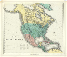
The Myths & Legends of the West Coast of America
Fascinating map of North America, highlighting the lack of information known about the American West at the outset of the American Revolution.
The Northwest Coast of America immediately pre-dates the reporting from Captain James Cook's first Voyage and includes the reported Russian Discoveries. The map also pre-dates the earliest maps to identify the Bay of San Francisco, which had been discovered by the Spanish in 1769, but not yet disclosed in Europe.
Among the more interesting features are the appearance of the mythical River of the West, which suggested that prospect of a continuous river from the Rocky Mountains to the Pacific Ocean, which was within reach from the upper Missouri or via the river system leading to Lake Superior and Hudson's Bay.
Along the coast, the mythical discoveries of Admiral De Font and Juan de Fuca are noted, along with the entrance to the River of the West sighted by Martin d'Aguilar in 1603 (mythical).
Drake's discovery of California in 1578 is referenced, along with Drake's Harbor.
Further north, the map gives a credible accounting of the known discoveries of the Russians in Alaska and the Arctic regions.
Most unusual is the reference to the "Land which is supposed to be discovered by the Fousang of the Chinese Geographers." This note reflected the belief that Chinese mariners might have reached America, the location of the mythical colony of Fou-sang. According to some historians such as Charles Godfrey Leland and Joseph de Guignes ( Le Fou-Sang des Chinois est-il l'Amérique Mémoires de l'Académie des Inscriptions et Belles Lettres, tome 28, Paris, 1761), the distances given by Hui Shen (20,000 Chinese li) would locate Fou-sang on the west coast of the American continent, near British Columbia.
Samuel Dunn (bap. 1723-1794) was a teacher of mathematics and navigation who published, among other things, maps and charts. Although information about his early education is lacking, by age nineteen he was leading his own school and teaching writing, accounting, navigation, and mathematics in Devon. In 1751, he moved to London, where he taught in several schools and tutored privately.
By the 1760s, Dunn was known as a respected astronomer and had published a range of textbooks on math, navigation, and astronomy. After the publication of the Nautical Almanac, Dunn acted as a certifier of ships’ masters under the new system, on behalf of the Board of Longitude. He performed similar work for the East India Company, as well as made charts of the East Indies. In 1776 he published A New Variation Atlas and, in 1777, A New Epitome of Practical Navigation, or, Guide to the Indian Seas. By 1780, he was named editor of the New Directory for the East Indies, which included his own charts. In 1786, he released a pioneering study, Theory and Practice of Longitude at Sea. He also designed several instruments for navigation.
Dunn died at his home in Fleet Street in January 1794. His books and maps were auctioned at Sothebys in a sale of over 1,000 lots. Many of these were bought by Alexander Dalrymple, hydrographer of the East India Company and soon-to-be-named first head of the Hydrography Office.