|
||

|

|
|

|
Stock# 53483
Description
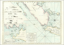
Rare separately issued sea chart of a part of the west coast of Malaysia, published in Japan by the Maritime Safety Agency of Japan, shortly after the Second World War.
The map extends from Pangkor Island to the mouth of the Perak River and then up river to Teluk Intan.
The map indicates that it is drawn from an 1935 British Admiralty Chart.
A very unusual chart -- the first we have ever seen.
Condition Description
Minor soiling and signs of use.
![[ Old Color! ] Nova Tabula Insularum Iavae, Sumatrae, Borneonis et Aliarum Mallaccam usquae delineata in insula Iava . . .](https://storage.googleapis.com/raremaps/img/small/78233.jpg)

![[Sulawesi] Kaart van Zuid West Celebes bevattende deGouvernemts. de Leenroerige en Een Gedeelte der Bondgenootschappelijke Landen behoorende tot het Gouvernements van Celebes en Onderh . . .](https://storage.googleapis.com/raremaps/img/small/51902.jpg)