


|
||

|

|
|

|
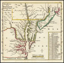
Scarce and highly detailed map of of the region extending from Lake Michigan to the St. Lawrence River and the Atlantic. The Ohio Indians ar noted, with numerous Indian Villages in Michigan and Ohio. Marvelous detail in Pennsylvania, New York, which extends to the North side of the St. Lawrende and New England. Heavily annotated throughout the map. The map also notes roads, rivers, mountains, lakes, towns, forts, Indian Settlements and a host of other important features. An excellent post-French & Indian War map.
John Gibson flourished in London from 1748 to 1773. He was most likely born ca. 1724. As a young man he was apprenticed to John Blunbell of the Stationers Company, and then to John Pine. He was made free of the Company in 1748. Gibson proved a talented geographer and engraver who produced numerous maps, especially for books and magazines. He worked in collaboration with other map sellers such as Emanuel Bowen and John Roque. His best-known work was the pocket atlas, The Atlas Minimus (1758). Although little is known about his life beyond his publications, he was imprisoned for debt in King’s Bench from May to June of 1765.

![[Theater of American Revolution / 1776] A Map of the Country round Philadelphia including Part of New Jersey New York Staten Island & Long Island](https://storage.googleapis.com/raremaps/img/small/86066.jpg)