|
||

|

|
|

|
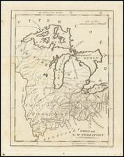
Fort Des Moines, Wisconsin Territory
Finely detailed map of the section of the Mississippi River, showing the Des Moines Rapids in the area of Fort Des Moines, based upon the surveys of Lieutenant Robert E. Lee of the US Corps of Engineers.
The Des Moines Rapids was one of two major rapids on the Mississippi River that limited Steamboat traffic on the river through the early 19th century. The Rapids between Nauvoo, Illinois and Keokuk, Iowa-Hamilton, Illinois is one of two major rapids on the Mississippi River that limited Steamboat traffic on the river through the early 19th century. The rapids just above the confluence of the Des Moines River were to contribute to the Honey War in the 1830s between Missouri and Iowa over the Sullivan Line that separates the two states.
The map shows the area between Montrose, Iowa and Nauvoo, Illinois in the north to Keokuk, Iowa and Hamilton, Illinois. On the west bank of the river, the names, Buttz, Wigwam, McBride, Price, Dillon, Withrow, Taylor, Burtis and Store appear. On the east bank, Moffat, Geo. Middleton, Dr. Allen, Grist Mill, Waggoner, Cochran, Horse Mill, Store, Mr. Phelt, and Mrs. Gray, the latter grouped around the town of Montebello.
The survey of the River was commenced by Napoleon B. Buford of the US Army Corps of Topographical Engineers in 1829 and corrected by Henry Miller Shreve in 1836. This particular survey was completed in 1837 by Robert E. Lee.
The map was published as part of a concerted effort between 1825 and 1843 to survey and improve commercial navigation and flooding on major American Rivers, undertaken by the US Army Corps of Engineers.
Fort Des Moines (1834-1837) was U.S. Army post established as Camp Des Moines in 1834 by Lt. Colonel Stephen Watts Kearny, 1st U.S. Dragoons, in Lee County, Iowa. The fort was located along the west bank of the Mississippi River at present-day Montrose. It was renamed Fort Des Moines in 1835 and abandoned in 1837.