|
||

|

|
|

|
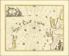
Highly detailed and decorative large format engraved map of the Caribbean by Herman Moll.
Moll's map was the most popular large English map of the Caribbean, Florida, the Gulf Coast, Texas, and Central America in its day. It was a central image in the British understanding of Spanish activity in the Caribbean, as the note at Cartagena illustrates:
At Cartagena the Gallions usually stay 60 days, and thence go to Portobel where they lye 30 days, and then return again to Cartagena; from whence they sail for the Havana, to meet there ye Flota, which is a finall number of Ships that go to la Vera Cruz to take in ye Effects of that Country.
The map includes insets of the harbors at St. Augustine, Vera Cruz, Havana, Porto Bella and Cartagena and a gorgeous view of Mexico City.
The map includes numerous annotations throughout. Curiously shaped Florida, which is unusually wide. Good internal cartography in Florida, Texas and the Gulf Coast, with interesting notes regarding the Spanish fort at Pensacola, the trade conducted between the Indians and the French and Spanish in Texas, A white Spaniard settlement in Texas on the Sivoras River, Colonel Moore's abandoned settlement in western Florida and a host of other details. The bay insets are very detailed and include soundings.
In this state, the imprint line reads:
Printed for Tho. Bowles in St. Pauls Church Yard and John Bowles at the Black Horse in Cornhill.
Thomas Bowles II and John Bowles were brothers, sons of the founder of the Bowles publishing house, Thomas Bowles I. John operated from the Black Horse beginning in 1733.
![[Restricted] New Orleans (0-6)](https://storage.googleapis.com/raremaps/img/small/68648.jpg)
![[ Texas Oil Map ] Map of Terrell County Texas](https://storage.googleapis.com/raremaps/img/small/102589.jpg)