|
||

|

|
|

|
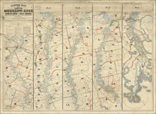
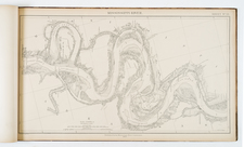
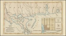
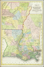
One of the earliest obtainable maps of the State of Louisiana
A rare early map of Louisiana, published by Fielding Lucas Jr. in Baltimore, from his New & Elegant General Atlas of the United States . . .
Includes a number of early roads, towns, rivers, Indian Tribes, settlements, etc. Many early Indian Villages also named.
This is the first time we have ever offered this map for sale.
Fielding Lucas, Jr. (1781-1854) was a prominent American cartographer, engraver, artist, and public figure during the first half of the 19th century.
Lucas was born in Fredericksburg, Virginia and moved to Philadelphia as a teenager, before settling in Baltimore. There he launched a successful cartographic career. Lucas's first atlas was announced in early- to mid-1812, with production taking place between September 1812 and December of 1813, by which point the engravings were complete. Bound copies of the atlas -- A new and elegant general atlas: Containing maps of each of the United States -- were available early in the next year, beating Carey to market by about two months. Lucas later published A General Atlas Containing Distinct Maps Of all the known Countries in the World in the early 1820s.