


|
||

|

|
|

|
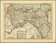
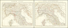
Detailed map of the northern parts of Italy, publisihed in London by Herman Moll.
The map details the intricate web of political boundaries in the northern part of Italy, highlighting the myriad states that existed before the unification of Italy in the 19th century. Each of the regions named in the title is depicted with unique characteristics that help to differentiate them from each other.
The Duchy of Savoy, for instance, is shown as a relatively large region, extending from modern southeastern France into the western part of Northern Italy, reflecting its historical significance as a bridge between France and Italy. The Duchy of Milan, a powerful state in its own right, is depicted as being located in the heart of the Lombardy region.
The smaller Duchies of Parma, Mantua, Modena, and Tuscany are also outlined, each with their own distinct borders, reflecting the intricate patchwork of independent states that characterized Italy during this period.
The map also showcases the powerful maritime republics of Venice and Genoa. Venice is depicted with its expansive lagoon and network of islands, while Genoa is represented as a coastal city-state with a large naval force, reflecting its historical role as a key Mediterranean power.
The Republic of Lucca, though small, is also marked. As a landlocked city-state, Lucca was known for its impressive walls and its wealth derived from the silk trade.
The map is imbued with a rich sense of the political landscape of the time, reflecting the competing interests and alliances between these regions. While it offers a fascinating glimpse into the past, it also serves as a reminder of the complex historical forces that have shaped modern Italy.
Herman Moll (c. 1654-1732) was one of the most important London mapmakers in the first half of the eighteenth century. Moll was probably born in Bremen, Germany, around 1654. He moved to London to escape the Scanian Wars. His earliest work was as an engraver for Moses Pitt on the production of the English Atlas, a failed work which landed Pitt in debtor's prison. Moll also engraved for Sir Jonas Moore, Grenville Collins, John Adair, and the Seller & Price firm. He published his first original maps in the early 1680s and had set up his own shop by the 1690s.
Moll's work quickly helped him become a member of a group which congregated at Jonathan's Coffee House at Number 20 Exchange Alley, Cornhill, where speculators met to trade stock. Moll's circle included the scientist Robert Hooke, the archaeologist William Stuckley, the authors Jonathan Swift and Daniel Defoe, and the intellectually-gifted pirates William Dampier, Woodes Rogers and William Hacke. From these contacts, Moll gained a great deal of privileged information that was included in his maps.
Over the course of his career, he published dozens of geographies, atlases, and histories, not to mention numerous sheet maps. His most famous works are Atlas Geographus, a monthly magazine that ran from 1708 to 1717, and The World Described (1715-54). He also frequently made maps for books, including those of Dampier’s publications and Swift’s Gulliver’s Travels. Moll died in 1732. It is likely that his plates passed to another contemporary, Thomas Bowles, after this death.
![[Savona Province and Environs]](https://storage.googleapis.com/raremaps/img/small/65400.jpg)
![[ Piedmont and Lombardy ] Nova et prae Caeteris Aliis Status et Ducatus Mediolanensis Permensis et ontis Ferrati. . .](https://storage.googleapis.com/raremaps/img/small/78747.jpg)