|
||

|

|
|

|
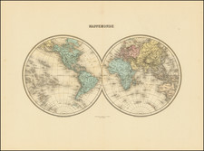
Dramatic double hemisphere map of the World, published in Leiden by Pieter Van Der Aa.
The map includes an unnamed set of sailing tracts. California is shown as an island. The Mississippi River and Great Lakes are based upon early 18th Century French sources.
A strange pair of coastlines appear in the northwestern part of the Western Hemisphere, likely relating to Compagnie Land and Terra Iesso, which appeared on many 17th maps to the northeast of Japan.
An incomplete Australia is shown, lacking a southern and eastern coastline, and a single New Zealand Coastline is shown, based upon Van Diemen's discoveries and a small unnamed section of the mythical southern continent remains to the west of the Straits of Magellan.
This stretch of land is identified as the land discovered by the Spaniard Hernando Galego in 1576, as sent to the region by the King of Spain. This is an inaccurate reference to the Mendaña expedition. Gallego served as a pilot on the 1567-69 Pacific voyage of Alvaro de Mendaña, during which the Solomon Islands and Guadalcanal were discovered, among others. Gallego grossly underestimated the archipelago’s distance from Peru, creating a misleading impression of the extent of the Pacific.
Pieter van der Aa (1659-1733) was a Dutch mapmaker and publisher who printed pirated editions of foreign bestsellers and illustrated books, but is best known for his voluminous output of maps and atlases. Van der Aa was born to a German stonecutter from Holstein. Interestingly, all three van der Aa sons came to be involved in the printing business. Hildebrand was a copper engraver and Boudewyn was a printer.
![[ World Atlas ] Geography Anatomized: or, A Compleat Geographical Grammer. Being a Short and Exact Analysis of the whole Body of Modern Geography... To which is subjoin'd the present State of the European Plantations in the East and West Indies, with a Reasonable Proposal for the Propagation of the Blessed Gospel in all Pagan Countries.](https://storage.googleapis.com/raremaps/img/small/85550.jpg)
![(Early Photographic Facsimile of the Mappamundi of Tunuslu Hajji Ahmed) Kemãl ile Naks Olinmis Cümle-I Cihãn Nemunesi [Fully Illustrated Exposition of the World in Its Entirety]](https://storage.googleapis.com/raremaps/img/small/66562.jpg)