The item illustrated and described below is sold, but we
have another example in stock. To view the example which
is currently being offered for sale, click the
"View Details" button below.
1795 Joseph Scott
$ 875.00


|
||

|

|
|

|
Stock# 52705
Description
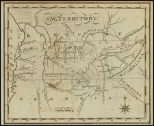
Pre-Dating The Establishment of Tennessee
Rare map of the region between the Appalachian Mountains and the Mississippi River, centered on the soon to be created state of Tennessee.
The map shows early roads, rivers and early settlements, along with the South Boundary of the Military Reservation. Early towns named include Nashville, Clarksville and Knoxville, along with a number of Indian villages.
Ross's Iron Works is located on the Holston River. As noted in Leander Bishop's A History of American Manufactures, 1608-1860, at page 614:
About the same time, if not earlier, Mr. David Ross, the proprietor of Iron-works in Campbell County, Virginia, erected a large furnace and forge at the junction of the North fork of the Holsten, with the main stream near the Virginia line. It was on the great road from Knoxvilie to Philadelphia. A bloomery was also set up, at this time, below the mouth of the Watanga, and another 25 miles above the mouth of French Broad, and 30 above Knoxville. Good ore was found in several places on the Holsten, and had been worked to advantage in one or two. Boats of 25 tons burden could ascend to Ross' Iron-works, nearly 1000 miles above the mouth of the Tennessee, and about 280 above Nashville. At Long Island, a short distance above, on the Holsten, where the first permanent settlement in Tennessee was made in 1775, boats were built to transport Iron and castings made in considerable quantities at these works, with other produce, to the lower settlements and New Orleans.
Condition Description
Minor foxing.
![[British Colonies in America] Carte Qui Contient Une Description Des Iles & Terres Que Les Anglois . . .[maps of Chesapeake, Carolinas, New England, Bermuda, Gulf Coast, Jamaica, Barbadoes & Canada]](https://storage.googleapis.com/raremaps/img/small/61480.jpg)
![[ Middle British Colonies Map ] Pensilvania Maryland and Virginia](https://storage.googleapis.com/raremaps/img/small/98228.jpg)