The item illustrated and described below is sold, but we
have another example in stock. To view the example which
is currently being offered for sale, click the
"View Details" button below.
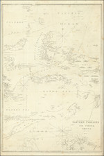
![[Philippine Islands] Carte du Canal des Iles Philippines Par leque passe le Galion de Manille. Et les Iles voisines de ce canal / Kaart van het Kanaal in de Filippynsche Eilanden . . . By George Anson](https://storage.googleapis.com/raremaps/img/small/76427.jpg)


|
||

|

|
|

|
Stock# 52682
Description
Scarce Dutch Edition of Anson's Map of the Philippines -- The Earliest Obtainable Large Map of the Philippines
Striking and highly detailed chart of the Islands of the Philippines from Anson's Voyages.
Anson's map of the Philippines is the earliest reasonably obtainable large format map of the Philippines. It is also one of the most detailed charts of the Philippines of the era. Shows Islands, bays, reefs, soundings tracks of the Manila Galleon route, etc. Includes a large compass rose and rhumb lines.
An essential map for Phillipine collectors.


![[Manila]. Die Befestigung der Hauptstadt Manila (Philippinen)](https://storage.googleapis.com/raremaps/img/small/86077.jpg)