|
||

|

|
|

|
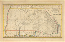
Colton's Large Sectional Map of Arkansas.
Colton's large and attractive 1884 map of Arkansas, one of the largest and most authoritative available at the time.
Shows railroads crossing the state. Counties and towns named. Arkansas borders Indian Territory.
Large, early maps of Arkansas are seldom encountered.
The Colton "New Sectional" maps are quite rare no matter their subject; we have handled only a few others (Illinois, Kansas, Minnesota, Michigan, and Florida). They deserve to be prized, as they are among the most detailed and authoritative map series for the post-Civil War United States.
G. W. & C. B. Colton was a prominent family firm of mapmakers who were leaders in the American map trade in the nineteenth century. The business was founded by Joseph Hutchins Colton (1800-1893) who bought copyrights to existing maps and oversaw their production. By the 1850s, their output had expanded to include original maps, guidebooks, atlases, and railroad maps. Joseph was succeeded by his sons, George Woolworth (1827-1901) and Charles B. Colton (1831-1916). The firm was renamed G. W. & C. B. Colton as a result. George is thought responsible for their best-known work, the General Atlas, originally published under that title in 1857. In 1898, the brothers merged their business and the firm became Colton, Ohman, & Co., which operated until 1901, when August R. Ohman took on the business alone and dropped the Colton name.

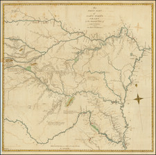
![[Jefferson's Notes on the State of Virginia] Observations sur la Virginie [with the map:] A Map of the country between Albemarle Sound, and Lake Erie, comprehending the whole of Virginia, Maryland, Delaware, and Pensylvania, with parts of several other of the United States of America. Engraved for the Notes on Virginia.](https://storage.googleapis.com/raremaps/img/small/51828.jpg)
![[ Map of the Mississippi River ]](https://storage.googleapis.com/raremaps/img/small/99811.jpg)