The item illustrated and described below is sold, but we
have another example in stock. To view the example which
is currently being offered for sale, click the
"View Details" button below.


|
||

|

|
|

|
Stock# 52588
Description
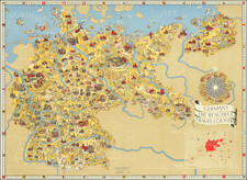
Striking propaganda and travel map of Germany, published by the Reichsbahnzentrale fur den Deutschen Reiseverkehr and the Geman Railways Information Bureau.
Text, map, and graphics on the verso.
Includes decorative border alternating crests and "Das Schöne Deutschland". Pictographs represent cities, cultural activities, agriculture, soldiers with Nazi flags, etc.
Decorative compass rose, highlighting German industry, etc. A smaller map shows Germany in red, with a Nazi flag in the center, prior to the commencement of its aggressive territorial expansion before and during WWII.
The map was also published in an English-language edition for the foreign market.
![(Germany) [Sketch and Albumen Print Album / Travels Along the Rhine River, including Nuremberg] Reis langs den Ryn Frankfort, Heidelberg, Munchen, Weenen, Tyrol, Salzburg, Dresden en de Sachsische Schweiz](https://storage.googleapis.com/raremaps/img/small/89724.jpg)
![(First World War - German Propaganda) Die Eisenbahn, der Lebensnerv des Heeres. [The railway, the lifeblood of the army.]](https://storage.googleapis.com/raremaps/img/small/89362.jpg)