|
||

|

|
|

|
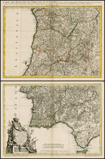
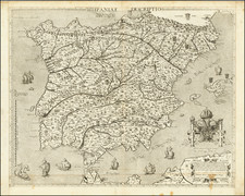
Two Maps of Portugal From the Collection of General Nicolas Charles Oudinot
Fine examples of the two most important maps of Portugal published in the latter part of the 18th century:
- First edition of Thomas Jefferys map rare map of Portugal, originally published in London in 1762.
- First edition of Thomas Lopez's map of Portugal, pubilshed in Madrid in 1778.
Jefferys Map of Portugal
Jefferys apparently collaborated with Miguel Rodrigues, who was then working as a printer for the Bishop of Lisbon, although Rodrigues connection to Jefferys and this map are unknown.
The map includes remarkable topographical detail, a large dedication cartouche and tables in English and Spanish. Dedicated to "the Right and Honourable John Earl of Bute".
Lopez Map of Portugal
Tomas Lopez's map is a fine amalgam of information from a number of sources, including:
- Carlos de Grandprez's Carta topográfica del patriarcado de Lisboa (1736)
- Pedro Gendrón's Mapa de Portugal (1754)
- Pedro Rodríguez de Campomanes Mapa de Portugal (1762)
- Jacques-Nicolas Bellin's Carte de Portugal (1762)
- Giovanni Rizzi-Zannoni's Carte de Portugal (1762)
- López also studied written accounts of the geography of Portugal, including Gaspar Estazo's Antigüedades de Portugal and Luís Caetano de Lima's Geografia historica
General Nicolas Charles Oudinot
A final detail that gives this map particular importance is the identity of its former owner, Nicolas Charles Oudinot, 1st Comte Oudinot, 1st Duc de Reggio (1767 - 1848), and a Marshal of France. A fierce fighter, the man was wounded no less than 34 times during his military career!
The only one of nine siblings to live past childhood, Oudinot joined the army without a noble pedigree, and therefore without a chance of high promotion. That all changed in 1792, with the outbreak of the French Revolution. In that year, Oudinot was elected lieutenant-colonel of the third battalion of the volunteers of the Meuse. After transfer to the regular army and admirable service in Belgium, he was promoted to the rank of general in June 1794 after the Battle of Kaiserslautern.
From Belgium he shifted to the German and Swiss fronts, where he fought as a general of division and chief of staff to Andre Massena. Oudinot stood out at the Battle of Monzambano so much so that Napoleon himself presented him with a sword of honor, now known as the Legion d'Honneur. Napoleon did not forget him after he established his empire; now Emperor Napoleon recognized Oudinot again, this time with a Grand Cross of the Legion of Honor.
During the Napoleonic Wars, Oudinot continued to acquit himself commendably. He was elected a member of the Chamber of Deputies, commanded a company of grenadiers nicknamed for him, and fought in battles from Vienna to Poland. In 1808, he was appointed governor of Erfurt and was made a Count of the French Empire. Finally, in 1809, after the Battle of Wagram, he was named a Marshal of France, France's highest military distinction.
Oudinot continued to serve as an administrator in Holland and on the battlefield in the Russian campaign. After Napoleon's fall, Oudinot joined the Bourbon Restoration and stayed loyal to the King even after Napoleon's return in 1815. For his loyalty and service, he was named a peer of the realm. He served until 1823, when he participated in the French invasion of Spain. Then, he turned again to political and administrative appointments; he died while serving as governor of Les Invalides, at the veterans' hospital in Paris.
Provenance
Purchased at auction in Paris, from Artcuriel, Collections from the Castle of Malicorne Marshal Oudinot's Historical Souvenirs, June 13, 2017 (Lot 156).
Thomas Jefferys (ca. 1719-1771) was a prolific map publisher, engraver, and cartographer based in London. His father was a cutler, but Jefferys was apprenticed to Emanuel Bowen, a prominent mapmaker and engraver. He was made free of the Merchant Taylors’ Company in 1744, although two earlier maps bearing his name have been identified.
Jefferys had several collaborators and partners throughout his career. His first atlas, The Small English Atlas, was published with Thomas Kitchin in 1748-9. Later, he worked with Robert Sayer on A General Topography of North America (1768); Sayer also published posthumous collections with Jefferys' contributions including The American Atlas, The North-American Pilot, and The West-India Atlas.
Jefferys was the Geographer to Frederick Prince of Wales and, from 1760, to King George III. Thanks especially to opportunities offered by the Seven Years' War, he is best known today for his maps of North America, and for his central place in the map trade—he not only sold maps commercially, but also imported the latest materials and had ties to several government bodies for whom he produced materials.
Upon his death in 1771, his workshop passed to his partner, William Faden, and his son, Thomas Jr. However, Jefferys had gone bankrupt in 1766 and some of his plates were bought by Robert Sayer (see above). Sayer, who had partnered in the past with Philip Overton (d. 1751), specialized in (re)publishing maps. In 1770, he partnered with John Bennett and many Jefferys maps were republished by the duo.
Tomás López de Vargas Machuca (1730-1802) was one of Spain’s most prominent cartographers in the eighteenth century. He was born in Toledo but studied at the Colegio Imperial in Madrid, where he focused on mathematics, grammar, and rhetoric. Along with a small group of colleagues, in 1752 the Spanish government sent López for training in Paris with the renowned geographer Jean Baptiste Bourguignon d’Anville. When he returned to Spain he was named Geógrafo de los dominios de Su Magestad and put in charge of the geographic collections of Charles III. He published many maps, including his fascinating maps of the Americas, and a variety of geography manuals. Some of his most famous maps are of the Iberian Peninsula, part of his large project to create a majestic atlas of Spain. Unfinished in his lifetime, López's children published the Atlas Geográfico de España (Geographical Atlas of Spain) in 1804. It was republished in 1810 and 1830.
![[Portugal / Morocco / Azores & Canary Islands] Pascaarte Van Barbarische cust mitsgaders van de Canarische en Vlaemsche Eijlanden](https://storage.googleapis.com/raremaps/img/small/75279.jpg)