|
||

|

|
|

|
Finely colored example of Blaeu's Maps of the Four Continents
Blaeu's maps of 4 continents are among the most iconic atlas maps of the Golden Age of Dutch cartography. The present set, drawn from the 1635 Latin edition of Blaeu's atlas, reflect the remarkable blend of cartographic detail and artistry characteristic of Blaeu's work.
America /gallery/detail/52415a
Blaeu's map of America is one of the most sought after maps of America from the Golden Age of Dutch Cartography, blending contemporary geographical knowledge and a rich decorative image. Blaeu's maps set the standard for the quality of the engraving, paper and color, as well as a fine depiction of contemporary geographical knowledge.
This map illustrates excellent detail throughout, including a classical rendition of the West Coast of America (which did not follow California as an Island myth) and dozens of place names along the East Coast. Nine decorative views of important American cities and harbors across the top and 10 fine miniatures of Native Americans of various regions along the side panels. The map is also embellished with eight sailing ships, four sea monsters and vignettes in the interior of the continent showing Indian life. Goss states, "this magnificent map sums up the general European view of the western hemisphere in the early seventeenth century…"
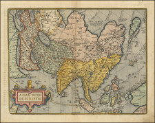
This map shows major Asian cities across the top and indigenous costumes along the sides. Korea is shown as a peninsula. Japan is oddly projected. Classic Northeast Passage shown, with a highly speculative and incomplete NE coast of Asia shown, opposite an equally conjectural piece of North America. Large portions of the Borneo coastline and other parts of the Islands in Southeast Asia and Australasia are incomplete or highly inaccurate.
The map is decorated with numerous sea monsters, sailing ships and a well-placed elephant above the source of the Ganges and illustration of the Great Wall of China.
Africa : /gallery/detail/52415d
This map shows major African cities across the top and indigenous costumes along the sides.
The body of the map is richly embellished with animals, including elephants, monkeys, ostriches, gazelles, lions, cheetahs and camels. In the oceans are numerous sailing ships, sea monsters, flying fish, and a gorgeous compass rose.
Europe /gallery/detail/52415b
The map shows 9 major European cities across the top and indigenous costumes along the sides.
The body of the map is richly embellished by sailing ships, sea monsters, animals and other curiosa.
Willem Janszoon Blaeu (1571-1638) was a prominent Dutch geographer and publisher. Born the son of a herring merchant, Blaeu chose not fish but mathematics and astronomy for his focus. He studied with the famous Danish astronomer Tycho Brahe, with whom he honed his instrument and globe making skills. Blaeu set up shop in Amsterdam, where he sold instruments and globes, published maps, and edited the works of intellectuals like Descartes and Hugo Grotius. In 1635, he released his atlas, Theatrum Orbis Terrarum, sive, Atlas novus.
Willem died in 1638. He had two sons, Cornelis (1610-1648) and Joan (1596-1673). Joan trained as a lawyer, but joined his father’s business rather than practice. After his father’s death, the brothers took over their father’s shop and Joan took on his work as hydrographer to the Dutch East India Company. Later in life, Joan would modify and greatly expand his father’s Atlas novus, eventually releasing his masterpiece, the Atlas maior, between 1662 and 1672.
![Western Hemisphere | Eastern Hemisphere [2 sheets]](https://storage.googleapis.com/raremaps/img/small/85676.jpg)
![La Florida [with] Guastecan [with] Peruviae Avriferae Regionis Typus](https://storage.googleapis.com/raremaps/img/small/89451.jpg)