|
||

|

|
|

|
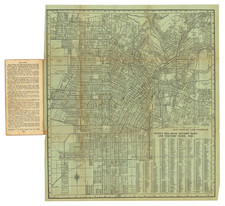
Re-Development of the Beverly Hills Speedway
Detailed map of a portion of Beverly Hills, California, showing 2 Tracts of Land, one of which had previously been the Beverly Hills Speedway.
The map shows the subdivision of the land bounded by Country Club Drive (now Olympic Blvd to the south), Beverly Drive (west), Wilshire Blvd (north) and Santa Monica Blvd (west), including the school site for Beverly HIlls High School (opened in 1927). Also included is the site of the Beverly Wilshire Hotel.
At the bottom right, the Terms of financing and basic zoning restrictions are shown.
In 1924, the 193 acres known as the Beverly Hills Speedway tract owned by Silsby Spalding, Cliff Durant, and Jake Dansinger was sold to Walter G. McCarty at about $10,000 per acre. By 1924, the entire Speedway property bounded by Wilshire Boulevard, South Beverly Drive, Olympic Boulevard, and Lasky Drive was developed into a proposed residential and business district.
The Beverly Wilshire Hotel was constructed by real estate developer Walter G. McCarty on the site of the former Beverly Hills Speedway. It was completed in 1928 and was then known as the "Beverly Wilshire Apartment Hotel".
The Beverly Hills Speedway operated from 1919 to 1924. During its brief history, it saw the establshment of several speed records and drew crowds as high as 85,000 for events. In 1924, it was sold to Walter G McCarty for $10,000 per acre.