


|
||

|

|
|

|
Important Atlas of Inner Austria
Rare late 18th Century set of 12 maps, typically referred to as the Atlas von Inner Osterreich (Atlas of Inner Austria).
The Atlas von Inner Osterreich is considered to be one of the most important cartographic works of the 18th Century for Austria.
The Atlas consists of a 12 map series (key sheet plus 11 maps) published for the first time between 1789 and 1797 by Franz Xaver Miller in Graz. The maps are drawn from the work of Joseph Karl Kindermann (1744-1801) and was engraved by Christoph Junker in Vienna. According to Dörflinger, the
Atlas Kindermanns und Millers is the most important regional group of maps from the second half of the 18th century in Austria (Dörflinger 1984, p. 110), along with Peter Anichs and Blasius Huebers
Atlas Tyrolensis (1774).
Joseph Karl Kindermann was born in Austria, and began his mapmaking career in 1768 working for the Dutch East India Company in South Africa as secretary of the governor J. van Plettenberg (from 1768). After his return to Europe, Kindermann continued to work in the field of geography and cartography.
The Atlas von Inner Osterreich is a loose map collection without its own title page. Only the dedication copy to Emperor Franz II in the Austrian National Library (ÖNB, FKB 280-11) includes a hand-written title page, provides information about the publisher, Franz Xaver Miller: "Atlas of Inner Austria. At the expense of Franz Xaver Miller, described as a "bürgerlichen Buchhändlers zu Graetz," as his contribution to the flowering arts of the Fatherland, and edited in 1797. "(Dörflinger 1995, p. 63).
The publisher Franz Xaver Miller was well connected in official circles, which gave Kindermann access to source information for the preparation of the maps.
The quality off the Atlas of Inner Austria is also confirmed by an encounter between Kindermann and Napoleon Bonaparte. Napoleon sent for Kindermann in 1797, since he wanted to get to know the man whose maps has so dramatically aided Napoleon in his Austrian campaign. In this conversation, Bonaparte was shocked to learn that "these maps were only the fruit of a private enterprise," that is, compiled without official or unofficial government funding or assistance.
Kindermann largely withdrew from public life until he was summoned to Vienna in the spring of 1801 to serve as chief editor for the "Atlas of the Austrian Empire" (Austrian National Atlas, 1805).
General Nicolas Charles Oudinot
A final detail that gives this map particular importance is the identity of its former owner, Nicolas Charles Oudinot, 1st Comte Oudinot, 1st Duc de Reggio (1767 - 1848), and a Marshal of France. A fierce fighter, the man was wounded no less than 34 times during his military career!
The only one of nine siblings to live past childhood, Oudinot joined the army without a noble pedigree, and therefore without a chance of high promotion. That all changed in 1792, with the outbreak of the French Revolution. In that year, Oudinot was elected lieutenant-colonel of the third battalion of the volunteers of the Meuse. After transfer to the regular army and admirable service in Belgium, he was promoted to the rank of general in June 1794 after the Battle of Kaiserslautern.
From Belgium he shifted to the German and Swiss fronts, where he fought as a general of division and chief of staff to Andre Massena. Oudinot stood out at the Battle of Monzambano so much so that Napoleon himself presented him with a sword of honor, now known as the Legion d'Honneur. Napoleon did not forget him after he established his empire; now Emperor Napoleon recognized Oudinot again, this time with a Grand Cross of the Legion of Honor.
During the Napoleonic Wars, Oudinot continued to acquit himself commendably. He was elected a member of the Chamber of Deputies, commanded a company of grenadiers nicknamed for him, and fought in battles from Vienna to Poland. In 1808, he was appointed governor of Erfurt and was made a Count of the French Empire. Finally, in 1809, after the Battle of Wagram, he was named a Marshal of France, France's highest military distinction.
Oudinot continued to serve as an administrator in Holland and on the battlefield in the Russian campaign. After Napoleon's fall, Oudinot joined the Bourbon Restoration and stayed loyal to the King even after Napoleon's return in 1815. For his loyalty and service, he was named a peer of the realm. He served until 1823, when he participated in the French invasion of Spain. Then, he turned again to political and administrative appointments; he died while serving as governor of Les Invalides, at the veterans' hospital in Paris.
Provenance
Purchased at auction in Paris, from Artcuriel, Collections from the Castle of Malicorne Marshal Oudinot's Historical Souvenirs, June 13, 2017 (Lot 156).
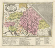
![[Austria] Partie Septentrionale Du Cercle D'Autriche, qui comprend L'Archiduche D Autrice divise en ses huit Quariers et La Haute Partie du Duche de Stirie . . .](https://storage.googleapis.com/raremaps/img/small/41724.jpg)
![(Inn Valley, Austria) Elegantissimus a parte Orientali Oenipontis prospectus. [An exquisitely beautiful view from the eastern part of Innsbruck.]](https://storage.googleapis.com/raremaps/img/small/94422.jpg)