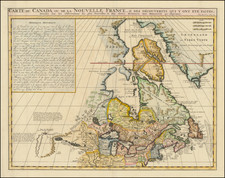
|
||

|

|
|

|
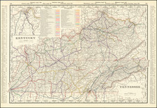
Nice example of the English edition of John Filson's map of Kentucky, published by John Stockdale in 1793.
Filson's map was first published in Wilmington in 1784, and is generally considered the first important map of Kentucky. The present example is very similar to the Wilmington edition but with minor alterations and an added inset, "A Plan of the Rapids in the River Ohio." Kentucky is shown divided into the counties of Lafayette, Lincoln and Jefferson and numerous settlements are located and named. The roads between the principal towns are shown by means of dotted lines, plus the following "Path of Cumberland Settlement, The Road from the Old Settlements in Virginia to Kentucky thro' the great Wilderness, Genl. Clark's War Road going, Birds War Road, &c." Kentucky was admitted as a State in 1792.
The Stockdale edition of Filson's map is the only full sized edition of the map other than the original 1784 Wilmington edition and the only other edition published in English. The last example of the map to appear at auction was the Thomas W. Streeter Copy (1967). In describing his copy, Streeter noted:
R. C. Ballard Thruston has given what is probably the definitive account of the Filson map in Filson Club History Quarterly, January, 1934, p. [1]--38. Mr. Thruston classifies the then 15 known copies of the map into six states. This map, so far as now known, is an intermediate unique example of state between Thruston's No. V and his No. VI. The main identification of state No. VI is the extension of the Sciota River through the north border of the map and the introduction of an Indian trail running south from the mouth of the Sciota to the Warrior's Path. Here the Sciota River extends through the north border but the Indian trail to the Warrior's Path is not yet shown.
John Filson
John Filson was born in Chester County, Pennsylvania, in 1747 and served as an Ensign in Montgomery's Pennsylvania Battalion of the Flying Camp and was taken prisoner at Fort Washington during Battle of New York in 1776. After the war, Filson worked as a surveyor in Pennsylvania until 1782 or 1783, when he acquired over 13,000 acres of western lands and moved to Kentucky. He settled in Lexington and travelled the region interviewing the settlers and leading citizens, where he wrote The Discovery, Settlement and Present State of Kentucke (1784). He also had his Map of Kentucke engraved and printed in Philadelphia. The book was almost immediately translated into French and re-published in Paris (1785) and somewhat later a German edition appeared (Leipzig, 1790).
After several years in Kentucky, Filson purchased from Mathias Denman a one third interest in an 800 acre tract at the junction of the Ohio and Licking rivers, the future site of Cincinnati, which he called Losantiville. Filson's survey and plan of the town survives in the layout of modern downtown Cincinnati. General Arthur St. Clair, Governor of the Northwest Territory, later changed the name of Losantiville to Cincinnati in honor of the Society of the Cincinnati, an organization of Revolutionary War officers founded by George Washington.
John Filson was born in Chester County, Pennsylvania, in 1747. Filson attended the West Nottingham Academy in Colora, Maryland, and studied with the Reverend Samuel Finley, afterwards president of the College of New Jersey (later Princeton). Heitman's Historical Register of Colonial Officers reports a John Filson served as an Ensign in Montgomery's Pennsylvania Battalion of the Flying Camp and was taken prisoner at Fort Washington during Battle of New York in 1776.
Filson worked as a schoolteacher and surveyor in Pennsylvania until 1782 or 1783, when he acquired over 13,000 acres of western lands and moved to Kentucky. He settled in Lexington, taught school, surveyed land claims, and travelled the region interviewing the settlers and leading citizens. He wrote The Discovery, Settlement and Present State of Kentucke (1784) during this period, and travelled to Wilmington, Delaware, to have it published in the summer of 1784. He also had his Map of Kentucke engraved and printed in Philadelphia. The edition, including both book and map, consisted of 1,500 copies and was priced at $1.50. The map was reprinted several times before 1793. Filson's plan for a second edition, to be endorsed by George Washington, was unsuccessful.
The book was almost immediately translated into French and re-published in Paris (1785) and somewhat later a German edition appeared (Leipzig, 1790). The appendix relating the adventures of Daniel Boone was extremely popular, and was referenced by (among others) Lord Byron in Don Juan.
Filson also wrote an unpublished manuscript entitled A Diary of a Journey from Philadelphia to Vincennes, Indiana, in 1785; An Account of a Trip by Land from Vincennes, hid., to Louisville, Kentucky, in 1785; A Journal of Two Voyages by Water from Vincennes to Louisville, and an account of an attempted voyage in 1786.
After spending several years in Kentucky teaching school, surveying, trying (unsuccessfully) to start a seminary, and becoming embroiled in numerous lawsuits and financial difficulties, he purchased from Mathias Denman a one third interest in an 800 acre tract at the junction of the Ohio and Licking rivers, the future site of Cincinnati, which he called Losantiville. Filson's survey and plan of the town survives in the layout of modern downtown Cincinnati. General Arthur St. Clair, Governor of the Northwest Territory, later changed the name of Losantiville to Cincinnati in honor of the Society of the Cincinnati, an organization of Revolutionary War officers founded by George Washington.
While on a surveying expedition near the Great Miami River, he disappeared, October 1, 1788, when his party was attacked by Shawnees.