


|
||

|

|
|

|
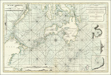
Rare Sea chart showing part of the Philippine Islands, Palawan, Borneo and contiguous islands, published by Laurie & Whittle in London.
The chart appeared in Laurie & Whittle's East India Pilot . . .
The chart is one of the most detailed sea charts of the region published in the 18th Century, and includes a number of annotations, including the tracks of a number of early explorers in the region.
At the edges of the chart, there are a nuimber of profile views, showing coastal features, along with plans of the Harbor of Silla in Mindanao, based upon the a chart by Jonathan Watson in 1762 and the Bay of Sooloo, taken by the Pecock in January of 1761.
The chart is very rare on the market. This is the second example we have seen in more than 15 years.
Richard Holmes Laurie (1777-1858) was the son of mezzotint engraver Robert Laurie, who had taken over Robert Sayer's publishing house with James Whittle in 1794. Richard Holmes Laurie joined in a partnership with Whittle when his father retired in 1812. The name of the firm then switched from Laurie & Whittle to Whittle & Laurie. Whittle died in 1818, leaving Richard Holmes to continue publishing alone as R. H. Laurie.
When the Hydrographic Office opened in 1795, it was tasked with creating and producing all the nautical charts for the Royal Navy so as to wean the Navy off dependence on foreign charts. By the 1820s, private publishers were augmenting HO charts and competing with them, including Richard Holmes Laurie. Richard gave up publishing anything except nautical materials by 1830. He also sold charts to Trinity House, the lighthouse and maritime safety fraternity. He died in 1858.
The firm continued to print under the name R.H. Laurie even after 1858. Later, the firm was managed by Laurie’s draughtsman, Alexander George Findlay, and, later, Daniel and William Kettle.
James Whittle (1757-1818) was a British engraver and map printer. Whittle was employed by Robert Sayer (ca. 1725-1794). Together with Robert Laurie (1755?-1836), he took on Sayer’s business when the older man died in 1794. The two traded together as Laurie & Whittle until 1812, when Laurie retired. They had specialized in sea charts and maritime atlases. Whittle then partnered with Laurie’s son, Richard Holmes Laurie, until he died in 1818.
![[ Philippine Islands ] This Pocket Map of Philippine Islands...](https://storage.googleapis.com/raremaps/img/small/94096.jpg)
![Belgium Foederatum auctius et emendatius… [Large inset of SE Asia]](https://storage.googleapis.com/raremaps/img/small/89316.jpg)