|
||

|

|
|

|
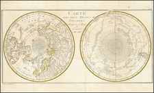
Alexander Mikhailovich Wilbrecht's First Map of the Northern Pacific Region
Rare separately published Russian map of the North Pacific and coastlines of Northwest America and Northeast Asia, synthesizing the best available information from Russian and European explorers between 1726 and 1779, composed by Alexander Mikhailovich Wilbrecht in 1787.
Alexander Wilbrecht was the most important mapmaker in Russia in the last decades of the 18th Century. The present map is Wilbrecht's first map of the Arctic Regions between Asia and America, and is generally regarded as the most important and detailed mapping of the Russian explorations in the region prior to Cook's arrival. The World Digital Library description of the map states:
This 1787 map shows the voyages of the leading Russian explorers of the North Pacific: Bering, Chirikov, Krenitsyn, Shpanberg, Walton, Shel'ting, and Petushkov. It also shows the 1778-79 voyage of British Captain James Cook. The route of each voyage is depicted in great detail, with ship locations plotted by the day. Other details on the map include administrative borders, population centers, Chukchi dwellings, and impassable ice. The inset map is of Kodiak Island, Alaska, denoted here by its Russian name of Kykhtak.
The inset map of Kodiak Island includes the explorations of Gerasim Ismailov, who after meeting Cook in 1778, explored the region in the 1780s. The map pre-dates the explorations of Dimitrii Bocharov and Grigorii Shelikov, who would later colonize Kodiak Island.
Among its more interesting features, the map includes a detailed treatment of the Russian regions in Northeast Asia and a remarkably detailed group of original Russian place names in Alaska and along the NW Coast of America. The map provides excellent detail in Alaska and along the Northwest Coast of America, reaching as far south as the Northern California, a foreshadowing of the Russian attempts at colonization along the California Coast.
In his catalog entry in 1980, Warren Howell notes:
An extremely important, and possibly unique chart showing the routes followed by the Russian navigators of the second half of the eighteenth century, including Bering and his assistants Chirikov and Spanberg, Walter, an Englishman, Schelting, a Dutchman, and Krenitsyn and Petuschkov. Of these, Bering and Chirikov explored the northwest coast of America in 1741, and Krenitsyn made an extensive reconnaissance of the Aleutian Islands in 1768, while others, like Spanberg, Walter, and Petuschkov visited Japan.
Of particular interest, and importance, is the large-scale inset map of the Kodiak and Afognak islands of Alaska. They were surveyed by Gerasim Izmaylov, the Russian whom Cook had met at Unalaska in October, 1778, and whose manuscript charts had impressed the English navigator as being far better than any he had seen previously. Izmaylov presented Cook with a chart of the area, but the Kodiak Island map did not appear on the large map of the North Pacific that accompanied the account of his last voyage. Both the principle chart and the inset provide details that do not appear on any other printed map of the period, providing the most complete cartographic representation of Russian knowledge of Alaska and the Northwest Coast prior to the last decade of the eighteenth century. A beautifully executed and historically significant map of which we have not been able to locate another copy.
There are two issues of the map. One is entirely in Russian and includes topographical detail in the Russia and Kodiak Island. Another is in French, but otherwise identical. The catalog entries for the maps noted below reference both maps as being published in St. Petersburg, with credit in the lower left corner to Wilbrecht and a credit to I.C. Nabholz as the engraver. Johann Christoph Nabholz is credited as one of the engravers who worked on Wilbrecht's Russian Atlas, Российский атлас из сорока трех карт состоящих и на сорок одну губернию Империю разделяющий.
List of Prior Explorations
The map lists and illustraties the following early voyages in the region:
- Vitus Bhering - 1728
- Vitus Bhering - 1741
- P. Chiriikow - 1741-42
- P. Krenitsyn - 1768
- M. Spanberg - 1738
- Walton - 1738
- A. Schelting - 1741
- Petrushkov - 1777
- James Cook - 1778-79
Alexander Wilbrecht
Alexander Wilbrecht (1757-1823) was a mathematician , geographer, cartographer and astronomer. Wilbrecht served as Geographer of The Geographic Department of the Cabinet of Her Imperial Majesty. In 1782, he produced the first Russian atlas. He also produced a number of important separately issued maps between 1787 and 1802. Wilbrecht is credited with authorship of several atlases, including Ross'iiskoi Atlas iz soroka chetyrekh kart sostaiashch'ii I na sorok na dva namiestnichestva Imper'iiu razdieliaushch'ii [The New Atlas or a Collection of all parts of the Globe], St. Petersburg, 1793 (Philips 679).
Provenance
The handwritten note at the top states: "Para o Senr. Dontor. Miguel Franzini Petersburgo 30 de Junho de 1788." This is a reference to Miguel Franzini, and Italian Mathematician who was, among other things, the tutor to the future King of Portugal (João VI) and professor at the Univesity of Coimbra.
Rarity
The map is very rare. We note copies in the Bibliotheque National de France, National Library of Australia and John Carter Brown Library. We also note the copy sold by Henry Stevens to Thomas Streeter in 1941 and resold at the Streeter sale in 1969, which appears to also be the Warren Howell copy noted above.
![[ Discovery of the Northwest Passage ] Chart Showing the Recent Search for a North-West Passage. Also the Coast Explored in Search of Sir John Franklin between the Years 1848 and 1854](https://storage.googleapis.com/raremaps/img/small/101874.jpg)