


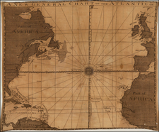
|
||

|

|
|

|
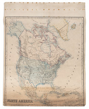
The Map That Launched The Mythical "Mr. Lawrence" and his visit to California.
Finely engraved map of North America, issued one year prior to the Louisiana Purchase, offering a fine template of the Northwestern region which would soon be visited by Lewis & Clark, Zebulon Pike, Jedidiah Smith and the Western Fur Trade.
The United States has expanded to 15 states, with the addition of Vermont and Kentucky to the original 13 colonies.
In the West, a massive lake appears in the land of the Doegg Indians, for which the map notes: "Lake &c. laid down according to Mr. Lawrence, who is said to have Travell'd through the Country to California in 1790 and 1791." While discussed in a number of American history books dating back to the early 20th century, there seems to be no source for this information, which most commonly is attributed to this map, although the date is given as 1811, when in fact as can be seen from this copy of the map, the legend may have begun as early as 1801.
To the south of this massive lake, which would become Lake Timpanagos, a smaller unnamed lake is shown, with the village of Teguayo shown at one of the southern Tributaries. In the coming years, this would become Lake Teguayo and be shown larger and farther to the west.
In the Canadian Arctic, the continuing search for the Northwest Passage is in evidence, although a long stretch of the coastline of the Arctic Sea is still unknown. The discoveries of MacKenzie in 1789 and Hearne in 1771 are shown, with extensive Indian details, topography and Hudson Bay Trading Posts or Forts shown.
The treatment of the region west of the Rocky Mountains is very sparse, pre-dating the combining of the Rocky Mountain chains in Colorado and the West into a single chain, as done by Humboldt in the following years. The present depiction shows exactly why the planners of the Lewis & Clark expedition would have held out hope of a continuous water course to the Pacific, via the Missouri River.
The detail on the west coast of North America reflects the expeditions of Cook and his contemporaries, but is curiously lacking the details of the Vancouver expedition and discovery of Vancouver Island. In California, San Francisco is newly added to the map., but virtually no interior information is given.
In Texas, a number of rivers and place names are given, with excellent details along the Rio Grande extending north to Santa Fe.
![[ Sea of the West ] L'Amerique Septentrionale divisee en ses principaux Etats . . . 1782](https://storage.googleapis.com/raremaps/img/small/80228.jpg)
