


|
||

|

|
|

|
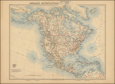
A Napoleonic General's Copy of Arrowsmith's Map of the Interior Parts of North America-One of the First Printed Maps to Show George Vancouver's Discoveries in the Pacific Northwest
Fine example of Aaron Arrowsmith's Map Exhibiting all the New Discoveries in the Interior Parts of North America, from the private library of General Nicolas Charles Oudinot, First Count of Oudinot, and First Duke of Reggio, Marshal of France.
Arrowsmith's map is the first to include Vancouver's voyage to the Pacific Northwest and the first map to show (but not name) the Columbia River. It was also the state recommended to Thomas Jefferson and which led Jefferson to use the fifth state of the map while planning the Lewis & Clark expedition.
The HBC, the Northwest Company, and Arrowsmith
Derived primarily from the field reports of the Hudson's Bay Company (HBC) and charts held by the Hydrography Office, Arrowsmith's map is generally considered one of the most important maps for the early history of the Trans-Mississippi West, Alaska and Western Canada. The map focuses on what is now Canada and points north, with the west coast charted from Cape Mendocino to Bering's Strait. The eastern side shows the shores of Greenland, across the Davis Strait to Labrador, down to Newfoundland and the eastern seaboard of the United States to New York. In the top center is an unframed cartouche proclaiming the title and dedication, to the governors of the HBC, who made "liberal Communications" with Arrowsmith.
Arrowsmith served as the unofficial cartographer to the HBC from 1795 onward; his family's firm supplied the Company with maps until 1859. This relationship allowed Arrowsmith access to otherwise private information. Indeed, the HBC was known for keeping its cartographic and natural historical information locked in Company archives, a policy that only changed under the governorship of Samuel Wegg from 1782 to 1799. Wegg also served as the treasurer of the Royal Society from 1768 to 1802, an affiliation that might explain his open attitude to sharing scientific knowledge.
Arrowsmith used HBC employee surveys and journals to map the central section of the chart, from Hudson's Bay west to the Stony Mountains. For the 1796 states, these surveyors include Philip Turnor, David Thompson, Peter Fidler, Samuel Hearne, Joseph Hawes, and Donald McKay. Of these Company employees, however, Hearne is perhaps the most significant.
Samuel Hearne was an HBC employee and was the first European to trek across what is now northern Canada to the Arctic Ocean. On three separate expeditions, Hearne, aided extensively by local indigenous peoples, explored the area west and northwest of Hudson's Bay. On the third trip, he and his guides followed the Coppermine River to Coronation Gulf. On his return south, in 1772, Hearne was the first European to see and cross the Great Slave Lake. Together, his expeditions proved that there was no Northwest Passage at lower latitudes. Hearne returned to England in 1787 and wrote his account of his journeys before dying in 1792. The account was published posthumously in 1795 and was a source for Arrowsmith, who issued an overlay showing Hearne's tracks to his 1795 map and integrated the findings on the 1796 states.
HBC employees, and their native informants, were not Arrowsmith's only sources for his cartography. Arrowsmith also enjoyed a good working relationship with the North West Company (NWC). Founded only in 1779, the NWC fought for trading posts and access to the Canadian interior with the HBC. One of their employees, Alexander McKenzie, traveled overland from Lake Athabasca, south of the Great Slave Lake, to the Arctic Ocean; his account gave Arrowsmith the information necessary to chart his course on this map. A note in the Arctic Ocean remarks that the strange animals that McKenzie assumed were whales where actually the sea-horses, or walruses, sighted by Cook on his third voyage.
Vancouver and the Pacific Northwest
For the regions farther west, Arrowsmith gained his intelligence from yet another institutional relationship, this time with the new British Hydrographic Office (HO). Founded only in 1795, the HO was headed by the formidable and skilled cartographer Alexander Dalrymple, who had been the Royal Society's first choice to command the Transit of Venus voyage that was eventually granted to James Cook. Dalrymple and Arrowsmith had a working relationship dating to at least 1790 and from September 1795 to November 1796 Arrowsmith was on the HO's payroll as a chartmaker.
Although dated with 'additions to 1796', this state actually was published in late 1798 or early 1799. The delay explains the differences in the second state, dated 1796, and this third state. Most of the differences stem from the publication of George Vancouver's account of his voyage to the Pacific Northwest in 1798. Vancouver himself had prepared the work, but he died in May of 1798, leaving his brother, John, to finish and see the text and charts through publication later that year.
Arrowsmith included Vancouver's track and borrowed several toponyms and geographic features from the navigator. For example, he changed Cook's River to Cook's Inlet and included a Russian Factory on the Inlet that Vancouver first observed. He also adopted Vancouver's intricate depiction of the Alexander Archipelago, as well as Puget Sound and the insularity of Vancouver Island.
However, not all of Vancouver's changes were taken on by Arrowsmith. Rather than use the name Kodiak Island, Arrowsmith stayed with the indigenous Kikhtak (or Kishtac as it is on the 1795 state) Island. Vancouver Island may indeed be insular, but rather than Vancouver's name Arrowsmith stayed again with the earlier name of Wakish Nation. Vancouver's "Quadra and Vancouver Island" is written in smaller font perpendicular to Arrowsmith's preferred name. Finally, Arrowsmith again adopted the geography of the Columbia River from Vancouver, in a distinctive "L" shape, but maintained his preferred name for the river, "R. Oregan."
The River Oregan
This river had featured in Arrowsmith's maps before. In a 1790 world map, Arrowsmith hypothesized that a "R. Oregan" flowed from eastern lakes to the Juan de Fuca Strait. In his 1794 world map, Arrowsmith removed the river from 49° N and added an unnamed river at 46° N; this is likely the first printed version of the Columbia River, information of which had arrived in London with Vancouver's lieutenants in 1793.
In 1798, Arrowsmith released a chart specifically dedicated to the Columbia River just after Vancouver's account was published. The account contained the first printed chart dedicated to the Columbia, an inset on a larger map of Pacific Northwest. Arrowsmith made a similar, but stand-alone, map which he called "Plan of the River Oregan." In an update of his 1794 world map released in the same year, 1798, Arrowsmith used both "Columbia R." and "R. Oregan."
The 1795 first state of this map shows the entrance to the Columbia and uses that name to describe it. Finally, in this third state, published in 1798 or 1799, Arrowsmith integrated Vancouver's information even more fully with regard to the shape of the river, but he returned to using "R. Oregan", perhaps in reference to his Plan and world map released the same year. It was not until the ninth state of this map, issued in 1814, that Arrowsmith finally adopted "Columbia River" and dropped his own "R. Oregan."
The further history of Arrowsmith's map: The Lewis & Clark expedition
Whereas many things on this general chart seem remarkably well-drawn for the time, other omissions jump out at the modern reader. For example, the Missouri River appears only as a river fragment. The Stony Mountains (Rocky Mountains) stop abruptly east of Lake Winnipeg. It is precisely these blank spaces that the Lewis & Clark expedition was supposed to fill.
Largely the brain child of Thomas Jefferson, the expedition set off in 1804 with a fifth state (1802) of this very map. However, it was most likely a 1796 state of the map that Julian Niemcewicz, the Polish writer, had in mind when he recommended Arrowsmith's map to Thomas Jefferson in a letter on August 2, 1800. Jefferson sought out the map and included a fifth state in the explorers' navigational kit for the journey. Additionally, multiple states of Arrowsmith's map were used by Nicholas King in his preparation of the primary manuscript map used on the Lewis & Clark Expedition.
General Nicolas Charles Oudinot
A final detail that gives this map particular importance is the identity of its former owner, Nicolas Charles Oudinot, 1st Comte Oudinot, 1st Duc de Reggio (1767 - 1848), and a Marshal of France. A fierce fighter, the man was wounded no less than 34 times during his military career!
The only one of nine siblings to live past childhood, Oudinot joined the army without a noble pedigree, and therefore without a chance of high promotion. That all changed in 1792, with the outbreak of the French Revolution. In that year, Oudinot was elected lieutenant-colonel of the third battalion of the volunteers of the Meuse. After transfer to the regular army and admirable service in Belgium, he was promoted to the rank of general in June 1794 after the Battle of Kaiserslautern.
From Belgium he shifted to the German and Swiss fronts, where he fought as a general of division and chief of staff to Andre Massena. Oudinot stood out at the Battle of Monzambano so much so that Napoleon himself presented him with a sword of honor, now known as the Legion d'Honneur. Napoleon did not forget him after he established his empire; now Emperor Napoleon recognized Oudinot again, this time with a Grand Cross of the Legion of Honor.
During the Napoleonic Wars, Oudinot continued to acquit himself commendably. He was elected a member of the Chamber of Deputies, commanded a company of grenadiers nicknamed for him, and fought in battles from Vienna to Poland. In 1808, he was appointed governor of Erfurt and was made a Count of the French Empire. Finally, in 1809, after the Battle of Wagram, he was named a Marshal of France, France's highest military distinction.
Oudinot continued to serve as an administrator in Holland and on the battlefield in the Russian campaign. After Napoleon's fall, Oudinot joined the Bourbon Restoration and stayed loyal to the King even after Napoleon's return in 1815. For his loyalty and service, he was named a peer of the realm. He served until 1823, when he participated in the French invasion of Spain. Then, he turned again to political and administrative appointments; he died while serving as governor of Les Invalides, the veterans' hospital in Paris.
Aaron Arrowsmith and the Arrowsmith Firm
Aaron Arrowsmith (1750-1823) was born in Durham in 1750. He came to London for work around 1770, where he found employment as a surveyor for the city's mapmakers. By 1790, he had set up his own shop which specialized in general charts. Arrowsmith's three shops were located on or near Soho Square, a neighborhood the led him to rub shoulders with the likes of Joseph Banks, the naturalist, and Matthew Flinders, the hydrographer. Through his business ties and employment at the HO, Arrowsmith made other important relationships with Alexander Dalrymple, the HBC, and other companies. In 1810 he became Hydrographer to the Prince of Wales and, in 1820, Hydrographer to the King.
He died in 1823, whereby the business passed to his sons, Aaron and Samuel, and, later, his nephew, John. Aaron Jr. (1802-1854) was a founder member of the Royal Geographical Society (RGS) and left the family business in 1832; instead, he enrolled at Oxford to study to become a minister. Samuel (1805-1839) joined Aaron as a partner in the business and they traded together until Aaron left for the ministry. Samuel died at age 34 in 1839; his brother presided over his funeral. The remaining stock and plates were bought at auction by John Arrowsmith, their cousin.
John (1790-1873) operated his own independent business after his uncle's death. After 1839, John moved into the Soho premises of his uncle and cousins. John enjoyed considerable recognition in the geography and exploration community. Like Aaron, John was a founder member of the RGS and would serve as its unofficial cartographer for 43 years. Several geographical features in Australia and Canada are named after him. He died in 1873 and the majority of his stock was eventually bought by Edward Stanford, who co-founded the Stanford's map shop that is still open in Covent Garden, London today.
States and rarity
According to Walker, Arrowsmith's map was published in nineteen known editions between 1795 and 1850. Aaron Arrowsmith worked on fifteen of these states before his death, after which his nephew carried on with additions and revisions.
The present example of the map is the third state, the second dated 1796. This state is also unrecorded by Stevens and Tree. The first 1796 state is differentiated from the 1795 by the shift of the Missouri River four degrees east and the addition of Fidler's track near the Stony Mountains. This second state has the Vancouver discoveries and track. The third state has an updated address for Arrowsmith; he moved from Charles Street, Soho to No. 24 Rathbone Place.
The 1796 states are also the earliest obtainable examples of the map. As noted by Warren Heckrotte:
Carl Wheat, in his description of this map, notes that he had never seen the 1795 first issue, such is its great rarity (OCLC lists only one copy, in Germany), and he quotes Henry Stevens, Son & Stiles, as stating that the 1795 issue was "so rare that we ourselves have never possessed a copy."
The 1795 first state is known in two examples and has never appeared on the market (British Library and Sachsische Landesbibliothek). For the three states of the 1796 map, OCLC locates copies at Harvard, the University of Iowa, the British Library, the Bibliotheque National de France, and the Library of Congress. Other than the Heckrotte sale, we note only one example of a 1796 state on the market in the past 30 years.
Provenance
Purchased at auction in Paris, from Artcuriel, Collections from the Castle of Malicorne Marshal Oudinot's Historical Souvenirs, June 13, 2017 (Lot 156).
Marshal Oudinot’s Historical Souvenirs, June 13, 2017 (Lot 156).
Raymond John Howgego, ed., “Vancouver, George,” in Encyclopedia of Exploration to 1800 (Potts Point, Australia: Hordern House, 2003), V13-V15.
Henry Stevens and Roland Tree, “Comparative Cartography exemplified in an Analytical & Bibliographical Description of nearly One Hundred Maps and Charts of the American Continent published in Great Britain during the years 1600 to 1850,” in Essays Honoring Lawrence C. Wroth (Portland: Frederick R. Goff, 1951), 305-363
James Walker, “Compiling ‘all the recent discoveries’: Aaron Arrowsmith and mapping Western North America, 1790-1823.” IMCOS 147 (2016): 25-40.
Greg Wood, “Successive States: Aaron Arrowsmith’s Chart of the Pacific Ocean, 1798-1832,” The Globe 70 (2012): 1-17.
Worms and Baynton-Williams, British Map Engravers, 25-9.
DeVoto, Westward the Course of Empire, p. 328 (1953).
The Arrowsmiths were a cartographic dynasty which operated from the late-eighteenth century to the mid-nineteenth. The family business was founded by Aaron Arrowsmith (1750-1823), who was renowned for carefully prepared and meticulously updated maps, globes, and charts. He created many maps that covered multiple sheets and which were massive in total size. His spare yet exacting style was recognized around the world and mapmakers from other countries, especially the young country of the United States, sought his maps and charts as exemplars for their own work.
Aaron Arrowsmith was born in County Durham in 1750. He came to London for work around 1770, where he found employment as a surveyor for the city’s mapmakers. By 1790, he had set up his own shop which specialized in general charts. Arrowsmith had five premises in his career, most of which were located on or near Soho Square, a neighborhood the led him to rub shoulders with the likes of Joseph Banks, the naturalist, and Matthew Flinders, the hydrographer.
Through his business ties and employment at the Hydrographic Office, Arrowsmith made other important relationships with Alexander Dalrymple, the Hudson’s Bay Company, and others entities. In 1810 he became Hydrographer to the Prince of Wales and, in 1820, Hydrographer to the King.
Aaron Arrowsmith died in 1823, whereby the business and title of Hydrographer to the King passed to his sons, Aaron and Samuel, and, later, his nephew, John. Aaron Jr. (1802-1854) was a founder member of the Royal Geographical Society (RGS) and left the family business in 1832; instead, he enrolled at Oxford to study to become a minister. Samuel (1805-1839) joined Aaron as a partner in the business and they traded together until Aaron left for the ministry. Samuel died at age 34 in 1839; his brother presided over his funeral. The remaining stock and copper plates were bought at auction by John Arrowsmith, their cousin.
John (1790-1873) operated his own independent business after his uncle, Aaron Arrowsmith Sr., died. After 1839, John moved into the Soho premises of his uncle and cousins. John enjoyed considerable recognition in the geography and exploration community. Like Aaron Jr., John was a founder member of the RGS and would serve as its unofficial cartographer for 43 years. Several geographical features in Australia and Canada are named after him. He carried the title Hydrographer to Queen Victoria. He died in 1873 and the majority of his stock was eventually bought by Edward Stanford, who co-founded Stanford’s map shop, which is still open in Covent Garden, London today.

![Trails: [1595-1945]: Land, Sea, and Air of The American Adventure Series](https://storage.googleapis.com/raremaps/img/small/70672.jpg)