|
||

|

|
|

|
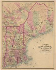
First state of Jeffery's map of New England and Nova Scotia, published by Thomas Jefferys in London.
A finely executed map, extending south to Massachusetts and west to Montreal and Lake Champlain. The map incorporates information from other contemporary maps, including Captain Durel's Chart for the eastern part of the map.
Within the map, a number of forts are listed, many of which include the date the forts were constructed (Frank Fort, 1732; Fort Western, 1754, Fort Halifax, 1754 etc.). Toward the top of the map, a line is shown, defining the limits of Cromwell's Grant of Nova Scotia in 1655.
The map of was compiled by the Irish cartographic genius Bradock Mead (alias John Green), who was responsible for many of the finest maps of North America of the period, while employed by Thomas Jefferys Sr. in London. The particular importance of Mead's work is the importance that he attached to the rigorous assessment of existing maps, edited with the latest astronomical observations, as noted in the a panel of text:. Throughout the map places where the latitude and longitude had been verified to his satisfaction were marked: 'Explanation A Single Stroke under the Name of a place denotes the Latitude being Observed, 2 Lines both Latitude and Longitude; a dotted line shews ye Observation doubtfull.'
One of the landmark maps of Nova Scotia and New England of the period.
Thomas Jefferys (ca. 1719-1771) was a prolific map publisher, engraver, and cartographer based in London. His father was a cutler, but Jefferys was apprenticed to Emanuel Bowen, a prominent mapmaker and engraver. He was made free of the Merchant Taylors’ Company in 1744, although two earlier maps bearing his name have been identified.
Jefferys had several collaborators and partners throughout his career. His first atlas, The Small English Atlas, was published with Thomas Kitchin in 1748-9. Later, he worked with Robert Sayer on A General Topography of North America (1768); Sayer also published posthumous collections with Jefferys' contributions including The American Atlas, The North-American Pilot, and The West-India Atlas.
Jefferys was the Geographer to Frederick Prince of Wales and, from 1760, to King George III. Thanks especially to opportunities offered by the Seven Years' War, he is best known today for his maps of North America, and for his central place in the map trade—he not only sold maps commercially, but also imported the latest materials and had ties to several government bodies for whom he produced materials.
Upon his death in 1771, his workshop passed to his partner, William Faden, and his son, Thomas Jr. However, Jefferys had gone bankrupt in 1766 and some of his plates were bought by Robert Sayer (see above). Sayer, who had partnered in the past with Philip Overton (d. 1751), specialized in (re)publishing maps. In 1770, he partnered with John Bennett and many Jefferys maps were republished by the duo.
![The Coast of Newfoundland From Plancentia to Cape Bonavista [and] A Draught of the River Plata in South America [and] Havana, Harbour [and] the Bay of Honda](https://storage.googleapis.com/raremaps/img/small/38599.jpg)

![[ Early United States ] Etats Unis De L'Amerique](https://storage.googleapis.com/raremaps/img/small/98746.jpg)