This item has been sold, but you can enter your email address to be notified if another example becomes available.


|
||

|

|
|

|
Stock# 51593ac
Description
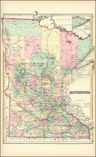
Rare, hand-colored lithographed folding map of Minnesota by the important Milwaukee publisher Silas Chapman.
Silas Chapman published his first map of Minnesota in 1856. That map focused primarily on the southeastern section of the state. The present 1869 edition stretches north to just above Duluth. Interestingly, Chapman has chosen to totally exclude the portion of the state that has not yet been surveyed, as alluded to in the title.
The large Sioux Reservation southwest of the Minnesota River is illustrated.
This edition was first copyrighted in 1865 and appeared in issues in 1866, 1868, 1869, 1870, and 1872. Today, all issues are scarce.
Condition Description
Publisher's hand-color by county. Folding map. Original gilt-lettered cloth folder.
![(Rochester, Minnesota) [Early letter -- Mary Hannak?]](https://storage.googleapis.com/raremaps/img/small/31788.jpg)

![Carte Qui Contient La Maniere Dont Se Fait La Chasse Des Bouefs Sauvages . . . [Buffalo, Niagara Falls, Calumet Village, Huron & Illinois Indians]](https://storage.googleapis.com/raremaps/img/small/93146.jpg)