


|
||

|

|
|

|
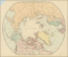
Fine early edition of Edward Stanford's map depicting the entire Arctic Region, featuring the furthest-most points reached by numerous exploring expeditions.
This fascinating map embraces the entire Arctic regions of the World, within a unique ovoid presentation. Centered on the North Pole, it variously extends as far south as 50 to 55 degrees North. All countries are distinguished by their own colors, and major geographic and oceanic features are labeled.
Most interesting, is the labeling of the furthest-most points of literally dozens of expeditions of discovery, along with the corresponding dates (printed in red). These extend chronologically from Sebastian Cabot's supposed visit to northern Newfoundland in 1497 to the Greely expedition of 1882. All the great names are mentioned, including Frobisher, Davis, Hudson, Baffin, Barents, Bering, Franklin, Nordenskjold, Ross and Peary, amongst many others. The American portion of the Bering Sea is labelled with information on the seasonal fishing restrictions. The amount of information featured on the map is truly extraordinary, and is unrivalled by any Arctic map of comparable size.
Most interestingly, it notes the expedition of Lt. Adolphus Washington Greely of the U.S. Navy in 1882. His party was the first to cross Ellesmere Island (which is shown here to be only partially mapped) and to reach a point of 83°23'8" North, the furthest-most Northern point ever reached to date. The North Pole itself would not be definitively reached until the Admunden expedition of 1928.
The map was issued in 1887 by Edward Stanford, then Britain's leading map publisher, in an effort to capitalize on the great contemporary interest in Polar expeditions, seen as the 'last frontier' in global exploration. Stanford had good connections with academic institutions such as the Royal Geographical Society and government bodies such as the Admiralty, so was always able to gain the most accurate information. The present map was one of Stanford's series of progressively updated maps of the Arctic Regions, the first of which was published around 1875, and the last issued in the 1930s.
The map is scarce on the market and was updated very frequently, making for a fascinating historical sequence of maps.
Edward Stanford (1827-1904) was a prominent British mapmaker and publisher. A native of Holborn in the heart of London, Edward was apprenticed to a printer and stationer at the age of 14. After his first master died, he worked with several others, including Trelawny W. Saunders of Charing Cross. Saunders oversaw young Edward’s early career, ensuring that he became a Fellow of the Royal Geographical Society. Associations with the Society eventually brought Sanders much business and gave him a reputation as a publisher of explorers. As testament to this reputation, the Stanford Range in British Columbia was named for him by John Palliser.
Stanford briefly partnered with Saunders in 1852 before striking out on his own in 1853. He was an agent for the Ordnance Survey, the Admiralty, the Geological Survey, the Trigonometrical Survey of India, and the India Office. He also controlled the maps of the Society for the Diffusion of Useful Knowledge, another lucrative source of income. In 1857, Stanford founded his namesake Geographical Establishment, with Saunders and A. K. Johnston as engravers. Thereafter, Stanford was known for his “library maps”, particularly those of Africa and Asia.
Addresses and Years of Operation:
- 6 Charing Cross, London (1848): Edward Stanford's initial place of employment at Trelawney Saunders' shop.
- 7 and 8 Charing Cross, London (1853): Stanford expanded his shop to these addresses.
- 55 Charing Cross, London (1873): The shop moved to this larger location.
- 12-14 Long Acre, London (1873): Site of the new print works and current flagship store.
- 7 Mercer Walk, London (2019): Stanfords moved to this address, continuing its legacy.
Stanford's work with Chief Cartographer John Bolton, including the 1858 Library Map of Europe, positioned the company as a leader in quality cartography during a time of exploration and colonialism. Their 1862 Library Map of London earned acclaim from the Royal Geographical Society. With the business thriving, Stanford purchased Staunton & Son in 1877 and, upon retiring in 1885, handed over the reins to his son, Edward Stanford II.
As sole agents for Ordnance Survey Maps, the company's influence and reputation grew, culminating in the Stanford’s London Atlas Of Universal Geography, which was presented to Queen Victoria in 1887. The transition into the 20th century saw further integration of retail, print, and cartographic operations at Long Acre.
During World War I, Stanford's became an essential publisher for the War Office. Edward Fraser Stanford took over in 1917, steering the company through the interwar period and innovations, such as the world’s smallest maps in 1922 and the Daily Mail Motor Road Map in 1926.
Withstanding a bombing in WWII, the company continued under the stewardship of John Keith Stanford and was sold to George Philip & Son in 1947. As it adapted to the digital age, Stanfords received the Ordnance Survey Premier Partner status in 2007 and ventured into online mapping and data services.
Stanfords, now an icon for travellers and explorers, has maintained its cultural relevance and retail success well into the 21st century, underpinned by a legacy of entrepreneurial spirit and commitment to cartographic excellence.
![[ Pacific Northwest - Northwest Passage ] Limes Occidentis Quivira et Anian. 1597](https://storage.googleapis.com/raremaps/img/small/71207.jpg)