This item has been sold, but you can enter your email address to be notified if another example becomes available.


|
||

|

|
|

|
Stock# 51481
Description
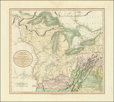
Decorative map of the Midwestern and Plains States, extending from the Great Lakes to Minnesota Territory and part of Nebraska and Indian Territory.
The map is centered on Lake Michigan and shows all of Minnesota Territory (with Dakota), Iowa, Missouri, Wisconsin, Michigan, Illinois, Indiana, Ohio and Kentucky.
Decorative border, with inset views of:
- Chicago
- Detroit
- Cincinnati
- St. Louis
A nice example of one of the most decorative travelers' maps of the Midwest published prior to the Civil War.
Condition Description
Minor staining along folds and a few minor spots.
![Reize door de binnenlanden van Noord-Amerika, door Jonathan Carver . . . [with map:] Kaart van Capitein Carvers Reize in de binnenlanden van Noord-America in 1766 en 1767](https://storage.googleapis.com/raremaps/img/small/86685.jpg)