![[ Patagonia - Straits of Magellan - Le Maire Strait ] Provinciae Sitae ad Fretum Magallanis itemque Fretum le Maire By Joannes De Laet](https://storage.googleapis.com/raremaps/img/small/74695.jpg)


|
||

|

|
|

|
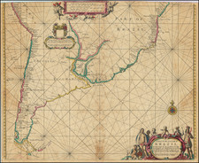
Important early map of the southern tip of South America, illustrating in detail the Straits of Magellan an the Straits of Le Maire.
The map was prepared by Hessel Gerritsz for Joannes De Laet's Nieuwe Wereldt ofte Beschrijvinghe van West-Indien ...., first published in Leiden in 1625.
Hessel Gerritsz, map maker for the Dutch VOC, prepared the present map from the information recently derived from the voyage of Jacob Le Maire and Willem Schouten, which resulted in the discovery of both the Le Maire Strait and Cape Horn. The present map is one of the earliest maps to focus on the region, appearing in De Laet's important compilation on the New World.
At the end of the sixteenth century, the Dutch began to challenge the Portuguese monopoly on trade routes to the East Indies. Individual Dutch syndicates organized and financed voyages to the East until 1602, when several syndicates combined to form the Vereenigde Oost-Indische Compagnie (also known as the Dutch East India Company or VOC). The Dutch government granted the VOC a trade monopoly for trade and travel to Southeast Asia by way of either the Cape of Good Hope around Africa or the Strait of Magellan in South America, which were the only known routes for the spice trade.
Isaac Le Maire, who was also engaged in trade in the Netherlands, set out to find a different route, in order to challenge the VOC stranglehold on the Dutch spice trade. As a director of the VOC, he had argued unsuccessfully to challenge the Spanish dominance of the western route via the tip of South America, which the VOC had not pursued, out of concerns for the Spanish control of the region. Le Maire started his Southern Company and set out to prove the existence of a passage to the Pacific to the south of the Magellan Strait. Le Maire obtained authorization from the Dutch government and enlisted Willem Cornelisz Schouten to join the venture. Schouten and Le Maire's oldest son Jacob set sale in June 1615, reaching the coast of South America on December 7, 1615. After the loss of one of the two ships on the voyage, the pair set sail southward and by January 20, 1616, they had passed the entrance to the Straits of Magellan, heading southward. Four days later, they encountered the an opening which would lead them through to the Pacific Ocean, which then named Le Maire Strait, in honor of Isaac Le Maire.
The voyage also established the wide distance between the tip of South America and the still unknown but hypothesized Terra Australis. Le Maire and Schouten continued their voyage across the Pacific, making a number of discoveries in the Tuamotu Archipelago and the Tonga Islands before sailing north of New Guinea to reach Java.