This item has been sold, but you can enter your email address to be notified if another example becomes available.


|
||

|

|
|

|
Stock# 51369
Description
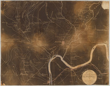
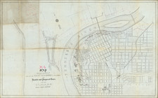
Scarce early map of Nashville, published by Tavel, Eastman & Howell in Nashville in 1879.
A highly detailed map of Nashville, showing streets, public buildings, topographical features and a host of other details.
Railroad lines shown include:
- Louisville & Nashville & Great Southern R.R.
- St. Louis & So. Eastern R.R.
- Nashville, Chattanooga & St. Louis R.R.
- Tennessee & Pacific R.R.
A number of early turnpikes are also shown, radiating outward from the city center.
The map also identifies a number of early land owners.