|
||

|

|
|

|
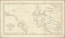
The First Attempt To Tunnel Through the Continental Divide
Rare separately published promotional map, showing the advantages of the Denver, Apex and Western Railway, via that Atlantic-Pacific Railway Tunnel.
The map highlights the 3 major routes from Denver to Salt Lake, keyed to the text box below:
- Union Pacific in Blue
- Denver & Rio Grande in Red
- Proposed Denver, Apex & Western Railroad in Black
The present map was published by Mark Pomeroy. In 1884 the Atlantic-Pacific Railway Tunnel Company was created "to drive a tunnel for both mining and railway purposes through the Continental Divide." Its properties consist of extensive and valuable real estate, mill sites, and mining claims, including the celebrated brought to her. This could only be done by tunnelling, and so Mr. Pomeroy conceived the idea of the Atlantic-Pacific Tunnel.
Pomeroy started prospecting and surveying and discovered that the distance through the great divide, from the base of Mount Kelso, under its apex, and on under the apex of Cray's Peak, was just under five miles. A tunnel through these mountains would enable Denver to have a gateway through the Rockies and shorten the railway distance between Denver and Salt Lake City by more than two hundred and fifty miles.
In all, Pomeroy raised nearly $2.4 Million, but the effort to complete the tunnel failed in part because of the Financial Panic of 1893, and it would be another 30 years before the Moffat tunnel would successfully complete the route from one side to another through the Continental Divide.
Rarity
The map is very rare. We note only a variant edition without text panel or color in the collections of the Denver Public Library and Yale.
![[Mormon Trail] Utah And the Overland Routes to it, from the Missouri River: Published with](https://storage.googleapis.com/raremaps/img/small/66366.jpg)