|
||

|

|
|

|
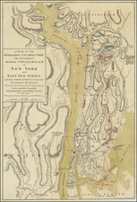
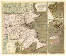
Des Barres Chart of Plymouth Bay, Cape Cod Bay and Duxbury Bay
Fine detailed sea chart of the area around Plymouth and Duxbury, Massachusetts, and covering Cape Cod Bay, Duxbury Bay and Plymouth Bay, published in London by Des Barres.
The map shows topographical features, the town of Plymouth, roads, buildings, soundings, farms and coastal features.
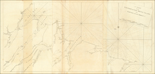
J.F.W. Des Barres and The Atlantic Neptune
Des Barres chart of Nantucket and Martha's Vineyard was issued both separately and in The Atlantic Neptune, an atlas of charts and views of North American waters used by British navigators throughout the Revolution. The charts were of an extraordinarily high quality and remained the standard for decades, becoming the standard reference work for cartographic information used by American and European engravers and publishers for decades thereafter. On a broad scale basis, it was not until the United States Coast Survey commenced issuing maps in the middle of the 19th Century that a more detailed and systematic charting of the Northeast was made under the auspices of a single project.
The charts of the Atlantic Neptune which focus on New England were based on work overseen by Samuel Holland, a Dutch-born surveyor and engineer who entered British service during the French and Indian War. After the war, Holland had proposed "an accurate and just Survey… upon… a general scale and uniform plan" of North America east of the Mississippi. This was to be a "geodetic" survey following the most advanced methods then in use in Europe, but applied for the first time in North America: the locations of control points would be established by rigorous astronomical observation, intermediate areas pinpointed by triangulation, and details sketched in from direct observation.
Holland's proposal was approved by the British Colonial offices, and in 1764 Holland was named Surveyor General of both the Province of Quebec and the Northern District of North America, from the Potomac to the border with Canada. After several years work in the Canadian Maritimes, from 1770-1774, he focused on the New England coast, making his headquarters in Portsmouth. From Portsmouth, Holland sent out survey teams headed by his deputies Charles Blaskowitz, James Grant, George Sproule, Thomas Wheeler and Thomas Wright, utilizing the sloop HMS Canceaux.
Holland's finished surveys were sent to England, where Des Barres oversaw the work necessary for their engraving and publication. The demand for charts was high in those unsettled times, and Des Barres' operation soon occupied two townhouses and 20 assistants in compiling, drafting and correcting the charts. While The Atlantic Neptune was usually made up to order and had no standard collation, it ultimately extended to five sections: Nova Scotia, New England, the River and Gulf of St. Lawrence (based on the work of James Cook), the coast south of New York, and American coastal views.
Joseph Frederick Wallet Des Barres (1721-1824) was born in either Paris or Basel, Switzerland, to a Hugueont family. He studied under the great mathematician Daniel Bernoulli at the University of Basel before immigrating to Britain, where he trained at the Royal Military College, Woolwich.
Upon the outbreak of hostilities with France in 1756, he joined the British Royal American Regiment as a military engineer. He came to the attention of General James Wolfe, who was impressed with his charting ability. During this period, he also worked with the legendary future explorer, James Cook, on a monumental chart of the St. Lawrence River.
Des Barres is best known for the Atlantic Neptune, was a remarkable, multi-volume set of sea charts and coastal views prepared from recent surveys, some of which were overseen by Des Barres in Nova Scotia after the Seven Years’ War. The maps, charts, and views were prepared under the supervision of Des Barres and employed as many as twenty engravers and assistants. They were produced over the course of a decade, from 1774 to 1784, in time to be used by the Royal Navy in the American Revolution.
After the Revolution, Loyalists were resettled throughout Canada. As part of this process, a new colony was created by separating Cape Breton from Nova Scotia. Des Barres, who already owned extensive lands in the Maritimes, served as lieutenant governor of Cape Breton Island from 1784 to 1787. He later served as governor of Prince Edward Island from 1804-1812.
Des Barres lived an exceptionally long life, even by today's standards, finally dying at age 102. Des Barres' funeral was held at St. George's Round Church in 1824 and he is buried in Halifax.
![[ The Finest Colonial New England Sea Chart of the 18th Century ] The Coast of New England](https://storage.googleapis.com/raremaps/img/small/63672.jpg)