


|
||

|

|
|

|
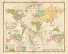
Fine World & Continents Set By Frederick De Wit
Finely colored set of maps by Frederick De Wit, representing the World and 4 continents at the height of the Golden Age of Dutch Cartography.
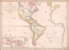
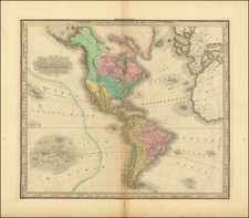
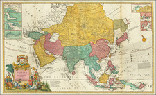
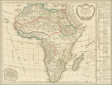
The set includes a stunning example of De Wit's world map, along with his maps of America (California as an Island), Asia, Europe and Africa.
Each map is embellished with striking cartouches and decorative vignettes, with the maps of America, Africa and Asia still reflecting a significant amount of the mythical and conjectural cartographic features which characterized the maps of the late 17th Century of these regions.
A finely colored set of these highly desirable maps. Individual images can be seen here:
World: /gallery/detail/50650mp2
America: /gallery/detail/50650mp2a
Asia: /gallery/detail/50650mp2c
Africa: /gallery/detail/50650mp2d
Europe: /gallery/detail/50650mp2b
De Wit (1629 ca.-1706) was a mapmaker and mapseller who was born in Gouda but who worked and died in Amsterdam. He moved to the city in 1648, where he opened a printing operation under the name of The Three Crabs; later, he changed the name of his shop to The White Chart. From the 1660s onward, he published atlases with a variety of maps; he is best known for these atlases and his Dutch town maps. After Frederik’s death in 1706, his wife Maria ran the shop for four years before selling it. Their son, Franciscus, was a stockfish merchant and had no interest in the map shop. At the auction to liquidate the de Wit stock, most of the plates went to Pieter Mortier, whose firm eventually became Covens & Mortier, one of the biggest cartography houses of the eighteenth century.
![Africa / Lybia / Morland / mit allen kunigsreichen so zu unsern zeiten darin gefunden werden [Afrika/Libyen/Morenland, with all the kingdoms found therein in our time]](https://storage.googleapis.com/raremaps/img/small/95771.jpg)