|
||

|

|
|

|
The First Map to Name Illinois
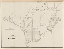
Nice example of John Gardiner's map of the Illinois Bounty Lands, the earliest obtainable map to name Illinois and an important map in the early settlement of Illinois Territory.
The map shows the area between the Mississippi River and the Illinois River, comprising much of the modern state of Illinois.
Streeter notes "[t]his is the first map that Phillips lists under Illinois and it is perhaps the first map showing a considerable part of Illinois with "Illinois" in the title". There are two editions of the map, one of which includes a printed grid.
The present example is signed by John Gardiner and includes a township grid with manuscript additions. This is the only example of this map we have ever seen with the grid. It would appear that the land granted under this map was in the Peoria area, just south of the confluence of the Illinois River and the Spoon River.
Following the War of 1812, there was a need to reward veterans and to continue the westward expansion process set in motion by President Jefferson, now that the results of the Lewis & Clark, Pike, Dunbar and Freeman & Custis expeditions had been published and the War with England resolved.
In May 1812, an act of Congress was passed which set aside bounty lands as payment to volunteer soldiers for the War against the British (War of 1812). The land was set aside in western territories that became part of the present states of Arkansas, Michigan and Illinois. One of the three districts (or "tracts") created to meet the warrants given in the War of 1812 was within a triangle of the Illinois Territory between the Mississippi and Illinois Rivers, which became known as the Illinois Bounty Lands. This area eventually became part of the state of Illinois in 1818 when Illinois became a state.
The General Land Office issued these patents in the Illinois Military Tract between October 1817 and January 1819. The lands were obtainable by veterans through a multi-step process beginning with the issuance of Bounty Land Warrants. The veterans applied for warrants and if an award was granted, used the Bounty Land Warrants to apply for land patents.
John Gardiner
John Gardiner was the chief clerk of the General Land Office during the War of 1812. Among the more noteworthy acts attributed to Gardiner was his removal of the General Land Office records from Washington by carriage, during the siege by the British, which saved them from destruction. His name appears on several early maps, including a Map of the Bounty Lands in Illinois Territory, a map of Northern Missouri, map of the military boundary lands in Arkansas Territory, and a map of of the Southern District of Alabama Territory (a companion map of the Northern District bears the name Peel & Sannoner, two Alabama surveyors who were responsible for the surveys which produced the map).
The Alabama maps bear the imprint of Tanner, Vallance, Kearney & Co. (Benjamin Tanner's firm) of Philadelphia, suggesting that it is likely that all 5 maps were printed in Philadelphia, as there were no printers working in Washington in this time frame who could have undertaken this project.
The map is rare on the market.

![Factors of Prosperity in the Rock Island-Frisco States of America [cover title]](https://storage.googleapis.com/raremaps/img/small/94604.jpg)