|
||

|

|
|

|
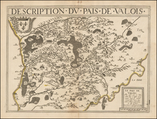
Scarce regional map of the Diocese of Senlis, with large inset plans of Senlis and Cresapy, by Guillaume De L'Isle, the most important and influential French mapmaker of the 18th Century. The map includes two large alphabetical tables, isting over 100 places with grid coordinates, a virtually never seen on 18th Century maps. At the bottom there is an advertisement and key to the symbols used on the map. The map is on a remarkably detailed scale for De L'Isle maps, showing towns, churches, woods, the smallest of roads and a host of other fine details. Attractive coat of arms at the top. An unusally early topographical map.
Guillaume De L'Isle (1675-1726) is probably the greatest figure in French cartography. Having learned geography from his father Claude, by the age of eight or nine he could draw maps to demonstrate ancient history. He studied mathematics and astronomy under Cassini, from whom he received a superb grounding in scientific cartography—the hallmark of his work. His first atlas was published in ca. 1700. In 1702 he was elected a member of the Academie Royale des Sciences and in 1718 he became Premier Geographe du Roi.
De L'Isle's work was important as marking a transition from the maps of the Dutch school, which were highly decorative and artistically-orientated, to a more scientific approach. He reduced the importance given to the decorative elements in maps, and emphasized the scientific base on which they were constructed. His maps of the newly explored parts of the world reflect the most up-to-date information available and did not contain fanciful detail in the absence of solid information. It can be fairly said that he was truly the father of the modern school of cartography at the commercial level.
De L’Isle also played a prominent part in the recalculation of latitude and longitude, based on the most recent celestial observations. His major contribution was in collating and incorporating this latitudinal and longitudinal information in his maps, setting a new standard of accuracy, quickly followed by many of his contemporaries. Guillaume De L’Isle’s work was widely copied by other mapmakers of the period, including Chatelain, Covens & Mortier, and Albrizzi.

![Carte Nouvelle Des Pais Bas Catholiques Devises en Autrichiens, Franscois en hollandois…MDCCXCII [New Map of the Catholic Low Countries Divided into Austrians, French and Dutch... 1792.]](https://storage.googleapis.com/raremaps/img/small/92341.jpg)