This item has been sold, but you can enter your email address to be notified if another example becomes available.


|
||

|

|
|

|
Stock# 50300
Description
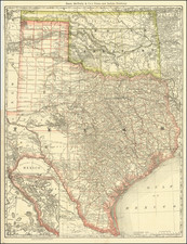
The Largest Sea Chart of the Gulf Coast Published During the Civil War
Highly detailed sea chart of the Gulf Coast, extending from Matagorda Bay in Texas to Appalachee Bay, published in New York by E. & G.W. Blunt.
Printed on 2 large sheets, Blunt's sea chart was the best map of the Gulf Coast available to mariners during the Civil War years.
The chart includes a large inset map of the area around Mobile Bay and a second inset showing a continuation of the Texas Coastline. The following authorities are listed for this chart:
- Major J.D. Graham
- Commodore Edwin Ward Moore of the (Republic of) Texas Navy
- JD Boylan
Improvements for the 1863 - 1864 additions are credited to Commodore Powell and Professor Coffin.
Blunt was the leading American chart maker during much of the 19th Century.
Condition Description
Repaired tear at left side of map, extending into the printed image, as illustrated.
![Charte von Den Vereinigten Staaten von Nord-America nebst Louisiana . . . 1805 [Rare 1st State of Gussefeld's Louisiana Purchase Map]](https://storage.googleapis.com/raremaps/img/small/63496.jpg)