|
||

|

|
|

|
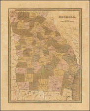
Rare First Edition of The Lucas Map of Georgia
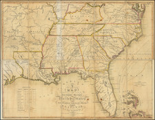
Nice example of Fielding Lucas' early map of Georgia, from his New & Elegant General Atlas of the United States . . .
The Western and Southern counties still do not appear and the region is dominated by Indian Lands. Several early towns appear in the west, along with a number of roads. Includes towns, counties, roads, rivers, mountains, forts and many other early details.
Along the bottom is a note identifying the "South Boundary of the United States," pre-dating the Adams Onis Treaty.
Striking example of Fielding Lucas' fine work, which distinguished him as the best publisher of the era. His maps are printed on a higher quality paper than contemporary maps by Carey & Lea and demonstrate a superior engraving quality and more attractive coloring style.
This is the first time we have ever offered this first edition of the map.
Fielding Lucas, Jr. (1781-1854) was a prominent American cartographer, engraver, artist, and public figure during the first half of the 19th century.
Lucas was born in Fredericksburg, Virginia and moved to Philadelphia as a teenager, before settling in Baltimore. There he launched a successful cartographic career. Lucas's first atlas was announced in early- to mid-1812, with production taking place between September 1812 and December of 1813, by which point the engravings were complete. Bound copies of the atlas -- A new and elegant general atlas: Containing maps of each of the United States -- were available early in the next year, beating Carey to market by about two months. Lucas later published A General Atlas Containing Distinct Maps Of all the known Countries in the World in the early 1820s.

![[North Carolina]. Carte Geographique, Statistique Et Historique De La Caroline Du Nord](https://storage.googleapis.com/raremaps/img/small/57603.jpg)