This item has been sold, but you can enter your email address to be notified if another example becomes available.


|
||

|

|
|

|
Stock# 50050
Description
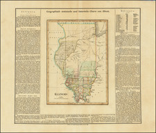
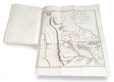
Scarce lithographed folding map of the Illinois River.
Shows the Mississipi from St. Louis to the junction with the Missouri and the course of the Illinois to Rockwell. The map names Peoria. It also shows the watersheds of several of the rivers that flow into the Illinois.
Extracted from the Report From The Secretary of War. . . transmitting a report of the survey of the Kaskaskia and Illinois rivers (Washington, D.C., 1838).
George Smith and M. H. Stansbury are also credited for the map.
Condition Description
Very light toning and foxing on the left side.
![[ Southern Railroads ] Railroad Map of the Southern States Shewing the Southern & Southwestern Railway Connections With Philadelphia. 1862 . . . Prepared by Thomas Kimber Jr., Chairman of the Committee on Inland Transportation of the Board of Trade of Philadelphia](https://storage.googleapis.com/raremaps/img/small/103211.jpg)