


|
||

|

|
|

|
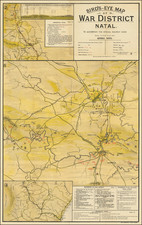
Rare Boer War Map Published By The London Geographical Institute
Detailed composite of three maps, describing the recent events of the Boer War. Particularly detailed is the central theme showing the activity around Colenso and Ladysmith, in the early months of 1900.
The main map shows battles around Ladysmith and references the site of the 'Armoured train disaster November 15th, 1899', which is the site of Winston Churchill's capture.
Map 2 shows Newcastle to Dundee with an inset profile view of Boer War positions from Colenso.
Map 3 shows the area to the west of Durban.
The present map is apparently quite rare, although it bears a striking resemblence to a similar map, published in Durban, South Africa, which appears with some frequency: https://exhibits.stanford.edu/maps-of-africa/catalog/fx940rh7963
![[Southern Africa] Kaart van het Zuidelykste Gedeelte van Afrika of het Land der Hottentotten](https://storage.googleapis.com/raremaps/img/small/89739.jpg)
![Juta's Map of South Africa From The Cape To The Zambesi Compiled from the best available Colonial and Imperial Information Including The Official Cape Colony Map By The Surveyor General, Cape Town, Dr. T.Hahn's Damaraland, And E.C.Selous' Journals & Sketches &c. New and Revised Edition .. . . 1889 [2 Sheets in slipcase]](https://storage.googleapis.com/raremaps/img/small/85389.jpg)