


|
||

|

|
|

|
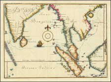
The First European map to show the Philippines in any form.
Fine example of Giacomo Gastaldi and Giovanni Battista Ramusio's engraved map of China, Southeast Asia, Japan and the Philippines, being the third of three maps intended by Ramusio to extend from Africa to Asia.
Ramusio depicts Southeast Asia as it was understood by Europeans in the middle of the 16th century. The map is oriented with south at the top. Ramusio was secretary of the powerful Consiglio dei Dieci (Council of Ten) of the Republic of Venice. In his position he had access to vast amounts new information comingfrom explorers, mariners and travelers returning to Europe from around the world. A geographer, travel writer and linguist, he compiled these into his seminal work Delle Navigationi et Viaggi.
Reamusio's map draws heavily from the voyage of Magellan. It provides an update from Gastaldi's of 1548, based upon new sources which became available during the intervening years.
Suarez notes that Ramusio's treatment of the region is a great advance from the 1548 map, relying upon Portuguese charts and the works of Joao de Barros as principal sources for the updates. Suarez discusses this map, the 1548 Geographia map and a later Lafreri map of 1561 in Chapter 11 of his work on the Mapping of Southeast Asia.
Among other important features of the map is that it is the first appearance of the name Philippines (Filipina) in any form on a European map. This map, which does not show Luzon, bears the name Filipina, applied to a narrow island to the east of Mindanao. The Spanish expedition leader Ruy Lopez de Villalobos bestowed the name Felipina on Leyte in honor of the young Crown Prince Philip (later Philip II) in 1543.
The map is also an important early map of Bengal. For the first time we see several cities in the interior of Bengal, drawn from the Portuguese historian Joao de Barros’ Decadas da Asia (c.1552). “The river of Caor”, de Barros narrates, “which traverses the kingdom so called (Gaur) and that of Comotay (Kamata), and that of Cirote (Sylhet), issues above Chatigao (Chittagong), in that notable arm of the Ganges which passes through the island of Sornagam (Sonargaon)”.
The Caor River is the named used by Ramusio for the Brahmaputra River. Sonargaon, an important inland port, administrative center and a onetime capital of the Bengal Sultanate is curiously illustrated as an island.
The map first appeared in the second edition of Volume I of Giovanni Battista Ramusio's Delle Navigation e Viaggi. The 1554 Ramusio-Gastaldi map not only benefited from Antonio Pigafetta's account of Magellan's voyage for its mapping of the Philippines but also relied on newly published sources at the time. Among these sources is the account of the voyage from Mexico to the Philippines by Juan Gaytan and Villalobos. Giovanni Ramusio was Secretary to the Council of Ten in Venice for 43 years and his collection of reports on voyages among the most important works of the period.
Giovanni Battista Ramusio (1485-1557) was an Italian geographer who worked within the Venetian Empire. His father had been a magistrate and he himself served as a civil servant to Venice. He served throughout Europe, allowing him to build up a network of informants and a collection of travel materials. He compiled this information into his enduring masterpiece, Navigationi et Viaggi, in 1550 (first volume) and 1556 (third volume). The second volume appeared after his death in 1559, as the original manuscript had been destroyed by a fire.
![[First Obtainable Map to Name California] Tartariae Sive Magni Chami Regni typus](https://storage.googleapis.com/raremaps/img/small/82510.jpg)
![(Russian Adventurism in China) Карта Средней Азии Составлена К. Веберомъ... 1871. [Map of Central Asia Compiled by K. Weber... 1871.]](https://storage.googleapis.com/raremaps/img/small/58597.jpg)
![Taisei Kyō Saiken Ezu [Detailed and illustrated map of Kyoto]](https://storage.googleapis.com/raremaps/img/small/58218.jpg)