|
||

|

|
|

|
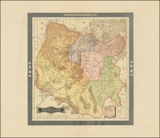
Fine Engraving of the Lago de Mexico and its Environs, now Drained
This engraving shows the environs around the Lago de Mexico. Now the lake is gone, drained over the course of several centuries to control flooding and allow for expansion.
The lake is criss-crossed by several bridges which connect towns floating on the water. Towns radiate from the lake, marked by tiny drawings of buildings. Many of the place names here are in nahuatl, the Aztec language, and are no longer in use. The largest of these is of course Mexico, known as Tenóchtitlan to the Aztecs. Mexico City lies in a valley, with mountains to the south, west, and east. Only to the north is there flat land (northeast) and grass land (northwest).
Draining the lake
The Lago de Mexico, also known as the Lago de Texcoco, was one part of a large lake system that used to be in central Mexico. Agriculture near the lake began 7,000 years ago with several early civilizations competing to control access and farming near its shores.
After the fall of Teotihuacan in 600-800 AD, several other city states fought for prominence in the region. In 1325 the Aztecs founded Tenochtitlan on the western side of the lake, developing their capital city on an island via a system of dams and canals. This city became the Federal District. There were large floating gardens, chinampas, on the lakes; they surrounded the capital city and were also prevalent in other shore areas. In addition to Texcoco, there were also parts of the lake system called Zumpango, Xaltocan, Xochimilco, and Chalco.
After the Spanish took Tenochtitlan, they never repaired the Aztec dams, making flooding a recurring problem in the region. To stem the floods, the Spanish attempted to drain the lake, with a major effort to divert water and improve drainage as part of the Bourbon reforms in the eighteenth century. This was called the Desag üe del Valle de México. However, drainage was not entirely successful until the mid-twentieth century. Now, the majority of the lake system is dry, with a considerable portion of the lake valley now serving as an urban area.
Historia de la conquista
The map was originally made in the sixteenth century, but it was also included in an edition of Antonio de Solís' Historia de la conquista de Mexico, poblacion y progressos de la America septentrional, conocida por el nombre de Nueva España. Solís (1610-86) was a historian and dramatist who served as chronicler of the Indies, or the official historian of the Spanish Empire. He published the Historia in 1684. It covers the three years from when Cortés was first appointed to command the Spanish invaders until the fall of Tenóchtitlan. The book was rapidly translated to French and Italian (1690s) and English (1738) and was reprinted many times in the eighteenth century. It served as the leading history of the Spanish Conquest until the nineteenth century.
This map was part of the new edition of 1704, published in Brussels by Francisco Foppens. Foppens (1685-1761) was a bookseller and publisher from a family of publishers who produced works in Spanish, French, and Latin. It was placed at page 272, as can be seen from the folio number in the upper right corner.
http://cvc.cervantes.es/obref/fortuna/expo/historia/histo015.htm
![[Mexico City and Environs] Mapa de las Lagunas, Rios y Lugares que Circundan a Mexico: para mayor inteligencia de la Historia y Conquista de Mexico que escribió Solis . . . 1783](https://storage.googleapis.com/raremaps/img/small/91029.jpg)
![Nouvelle Carte Du Mexique, Du Texas Et D'Une Partie Des Etats Limitrophes . . . 1840 [Proposed Railroads In Texas -- First Appearance of Arizona on a Printed Map]](https://storage.googleapis.com/raremaps/img/small/103480.jpg)
![[ Aztec Plan of Mexico City ] Facsimile of Page 1 of the Mendoza Collection of Mexican Picture paintings... | Mendoza Col Selden MSS. 3134.](https://storage.googleapis.com/raremaps/img/small/102305.jpg)