This item has been sold, but you can enter your email address to be notified if another example becomes available.


|
||

|

|
|

|
Stock# 49208
Description
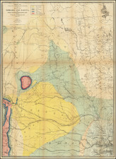
Rare map of the Mid-Continent, extending west to Salt Lake and Idaho, published in New York by H.S. Stebbins.
The map includes early appearances of Colorado Territory (1861) and Montana Territory.(1864).
The map is most noteworthy for its unusual configuraton for Dakota Territory, pre-dating the formation of Wyoming.
Montana has only 9 counties, predating the formation of Musselshell and Meaghter Counties in 1866.
The map is drawn from a wall map which includes decorative vignettes, including a Buffalo Hunt in Northern Nebraska and Elk in eastern Colorado.
![[ Ohio - Seven Ranges ] Plat of the Seven Ranges of Townships being Part of the Territory of the United States N.W. of the River Ohio which by a late act of Congress are directed to be sold . . . 1785](https://storage.googleapis.com/raremaps/img/small/82394.jpg)