


|
||

|

|
|

|
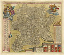
Fine example of Jansson's rare modern view of Rome, from his Theatrum Celebriorum Urbium Italiae, Aliarumque In Insulis Maris Mediterranei.
Striking bird's-eye plan of Rome with decorative title cartouche, showing the city as it was c. 1550. Included are various surviving features of ancient Rome: the surrounding walls, the Pantheon, the Coliseum, the Arch of Constantine, and the Forum Romanum. In the left corner in the foreground can be seen the Papal Palace and the Obelisk from the circus of Caligula and Nero.
A fine example of this scarce view.
Jan Janssonius (also known as Johann or Jan Jansson or Janszoon) (1588-1664) was a renowned geographer and publisher of the seventeenth century, when the Dutch dominated map publishing in Europe. Born in Arnhem, Jan was first exposed to the trade via his father, who was also a bookseller and publisher. In 1612, Jan married the daughter of Jodocus Hondius, who was also a prominent mapmaker and seller. Jonssonius’ first maps date from 1616.
In the 1630s, Janssonius worked with his brother-in-law, Henricus Hondius. Their most successful venture was to reissue the Mercator-Hondius atlas. Jodocus Hondius had acquired the plates to the Mercator atlas, first published in 1595, and added 36 additional maps. After Hondius died in 1612, Henricus took over publication; Janssonius joined the venture in 1633. Eventually, the atlas was renamed the Atlas Novus and then the Atlas Major, by which time it had expanded to eleven volumes. Janssonius is also well known for his volume of English county maps, published in 1646.
Janssonius died in Amsterdam in 1664. His son-in-law, Johannes van Waesbergen, took over his business. Eventually, many of Janssonius’ plates were sold to Gerard Valck and Pieter Schenk, who added their names and continued to reissue the maps.
![[Ancient Rome] La figure de la place ou fut iadiz la cite de Rome avec ses portes, quand elle estoit en la grand fleur](https://storage.googleapis.com/raremaps/img/small/64173.jpg)
![Veduta del Prospetto Principale della Colonna Antonina. [A Frontal View of the Column of Marcus Aurelius.]](https://storage.googleapis.com/raremaps/img/small/101718.jpg)
![Veduta di Piazza Navona sopra le ravine del Circo Agonale [View of the Piazza Navona above the Ruins of the Circus Agonalis; Circus of Domitian]](https://storage.googleapis.com/raremaps/img/small/93192.jpg)
![[ Ancient Rome ] Urbis Romae Situs Cum IIS Quae Adhuc Conspiciuntur Veter Monumet Relquiis Pyrrho Ligiorio Neap Invent. Romae M. D. LXX](https://storage.googleapis.com/raremaps/img/small/96880.jpg)
![Veduta del tempio della Sibilla in Tivoli [View of the Temple of the Sibyl in Tivoli]](https://storage.googleapis.com/raremaps/img/small/93189.jpg)